
Langtang Valley Trek

Trip Difficulty: Easy

Trip Days:9

Max Elevation: 4984m

Daily Activity: 5-6 hours Trek

Trip Starts: Syabrubesi

Trip Ends: Syabrubesi
Follow the Langtang Khola from subtropical forest to Kyanjin Gompa
The Langtang Valley Trek begins with a road journey north from Kathmandu and ends in a broad alpine valley beneath Langtang Lirung. It is one of the few major Himalayan routes that can be reached without a domestic mountain flight, yet the change in landscape is immediate once the walking begins. From Syabrubesi, the trail follows the Langtang Khola through forest, crosses suspension bridges and climbs past small lodge settlements before reaching the open ground around Langtang Village and Kyanjin Gompa.
Langtang is often introduced as the nearest major trekking region to Kathmandu. That description is useful, but incomplete. The attraction is not merely convenience. The valley has its own physical and cultural identity: Tamang villages with strong Tibetan Buddhist influence, yak pastures above the tree line, glacial systems descending from Langtang Lirung and a trail that remains quieter than the best-known routes in Everest and Annapurna.
Kudos Expeditions’ 9-day program follows the standard out-and-back valley route. After the drive to Syabrubesi, trekking days lead through Lama Hotel, Ghodatabela and Langtang Village to Kyanjin Gompa at about 3,870 metres. An additional day is reserved for acclimatization and a high viewpoint. When weather, snow and individual condition allow, the objective is Tserko Ri, listed on the live trip page at 4,984 metres.
Tserko Ri changes the grade of the journey. Walking to Kyanjin Gompa alone is a moderate teahouse trek. Climbing from the village to a point close to 5,000 metres requires a predawn start, sustained ascent, exposure to wind and a long return. It should remain optional. Kyanjin Ri or a shorter valley walk provides a sensible alternative when conditions are poor or a trekker is not sufficiently acclimatized.
The route does not involve technical climbing. There are no ropes, fixed lines or glacier crossings on the standard trail. The challenge comes from altitude, consecutive walking days, steep forest sections and the viewpoint climb. Good fitness helps, but controlled pacing and honest symptom reporting matter more than speed.
The journey also carries recent history. Langtang Village was devastated by the earthquake and avalanche of April 2015. The present settlement reflects years of rebuilding by local families. Visitors should approach this history with care. The village is not a disaster attraction; it is a living community whose lodges, farms and religious places support daily life in the valley.
Kudos Expeditions arranges road transport, park documentation, teahouse stays, trekking meals and local staff according to the confirmed package. On the trail, the guide manages pace, accommodation and safety decisions while creating time to understand the valley rather than treating Kyanjin Gompa as a checkpoint.
Langtang Valley Trek at a glance
| Trip detail | Information |
| Region | Langtang National Park, Rasuwa District, Nepal |
| Trip duration | 9 days |
| Trekking days | Usually 6–7 days, plus road travel |
| Starting point | Syabrubesi |
| Finishing point | Syabrubesi |
| Highest overnight | Kyanjin Gompa, about 3,870 m |
| Maximum optional elevation | Tserko Ri, 4,984 m on the Kudos page |
| Typical walking time | 5–7 hours per day |
| Difficulty | Moderate |
| Accommodation | Hotel in Kathmandu and teahouses on the trail |
| Main communities | Tamang, with Tibetan Buddhist cultural influence |
| Primary protected area | Langtang National Park |
| Best-known seasons | March–May and September–November |
| Main peaks | Langtang Lirung, Dorje Lakpa, Gangchempo, Yala Peak and Naya Kanga |
Why choose the Langtang Valley Trek?
Langtang provides a substantial mountain journey without the domestic flight logistics associated with Everest. The road from Kathmandu is long and can be rough, but it gives the operator alternatives when weather grounds aircraft elsewhere in Nepal.
The route gains altitude in a clear sequence. Forest dominates the lower trail. The valley opens near Ghodatabela, cultivated land and stone houses appear around Langtang Village, and the final approach to Kyanjin crosses yak pasture beneath glaciated peaks. The scenery changes enough to make the return walk feel different, even though much of the route is retraced.
The cultural setting is equally important. Tamang language, architecture, food and Buddhist practice remain visible along the trail. Mani walls, chortens and prayer wheels are not decorative additions for visitors. They belong to the religious landscape of the communities through which the trek passes.
For travellers with limited time, Langtang offers an efficient balance. A nine-day program can include road access, five principal mountain stages and a dedicated acclimatization day. It is shorter than many Everest or circuit itineraries but still reaches an optional viewpoint near 5,000 metres.
The valley also supports varied extensions. Travellers with more time can connect Langtang with the sacred lakes of Gosainkunda, the Helambu region, the Tamang Heritage Trail or more demanding high-pass routes. These additions should be planned as separate itineraries rather than compressed into the standard nine-day trek.
Trek highlights
- Trek through Langtang National Park, Nepal’s first Himalayan national park.
- Follow the Langtang Khola through oak, pine, rhododendron and bamboo forest.
- Visit Langtang Village and learn about the community’s reconstruction after the 2015 disaster.
- Spend two nights in Kyanjin Gompa beneath Langtang Lirung and surrounding glaciers.
- Attempt Tserko Ri at 4,984 metres when weather and acclimatization permit.
- Choose Kyanjin Ri or a shorter valley walk as an alternative high-day objective.
- See yak pastures, mani walls, chortens, monasteries and traditional stone settlements.
- Taste locally produced cheese when the Kyanjin dairy is operating.
- Trek without using a domestic mountain flight.
- Travel in a small group with local guide and porter support.
Understanding the Langtang Route
Syabrubesi and the lower gorge
Syabrubesi sits where several trekking routes and river valleys meet. The walking trail enters a steep gorge almost immediately, which means the first day feels more enclosed than the later valley stages.
Bamboo and mixed forest thrive at lower elevations. Rain and humidity can make this section muddy, while winter shade keeps some surfaces icy. The river remains close for much of the climb, sometimes visible below and sometimes heard through the trees.
Ghodatabela and the opening valley
Ghodatabela marks a visible shift from forest to broader grazing land. The name is commonly associated with a horse stable, and the surrounding terrain has long been used for seasonal livestock movement.
From this point, the route feels less like a gorge walk. Mountain views become more frequent, settlements are spaced across the valley floor and Buddhist structures begin to guide the line of the trail.
Langtang Village and the 2015 earthquake
On 25 April 2015, the Nepal earthquake triggered a massive avalanche and landslide from the slopes above Langtang Village. The disaster killed residents, trekking staff and visitors and destroyed much of the original settlement.
The rebuilt village demonstrates recovery, but the story should not be used as dramatic decoration. Travellers contribute most constructively by staying in local lodges, buying local products, listening when residents choose to speak and respecting memorial areas.
Publishing teams should avoid claims that every resident wants to discuss the earthquake. Cultural sensitivity is stronger than turning private loss into a compulsory tour narrative.
Kyanjin Gompa
Kyanjin is the final large lodge settlement on the standard route. Its name refers to the monastery, although the modern village also includes teahouses, bakeries, small shops and seasonal dairy production.
Two nights here are important. The first afternoon allows basic acclimatization after reaching 3,870 metres. The second day creates time for a viewpoint without moving the sleeping elevation higher.
The upper valley is exposed to wind. Sun can feel strong in the middle of the day, while shade and evening temperatures remain cold. Warm layers must stay accessible even during apparently stable weather.
Tserko Ri, Kyanjin Ri and Acclimatization Choices
Tserko Ri
Tserko Ri is a trekking summit rather than a technical climbing peak, but the height and duration make it demanding. The route climbs more than 1,100 vertical metres from Kyanjin Gompa and can be affected by snow, strong wind and limited visibility.
The climb should begin early because afternoon cloud and wind are common. There is little shelter above the valley floor, and the descent still requires several hours after the high point has been reached.
Different maps and operators publish slightly different elevations for Tserko Ri. The live Kudos page uses 4,984 metres, and the trip facts should remain consistent with that figure unless the company standardises its mapping data to another surveyed source.
Kyanjin Ri
Kyanjin Ri rises directly above the village and offers a shorter viewpoint option. Published elevations vary because the ridge has lower and upper points. The guide should state which point is intended rather than promising one universal summit height.
For many trekkers, the lower viewpoint provides sufficient mountain and glacier views without the full commitment of Tserko Ri. It is a sensible choice during marginal weather or when a person has mild altitude symptoms that have not worsened.
Langshisha Kharka and lower valley walks
A walk east toward Langshisha Kharka follows the upper valley with less steep ascent. Distance and river conditions determine how far the group travels. This option provides active acclimatization and extended views without forcing a summit attempt.
Difficulty, Altitude and Training
How difficult is the Langtang Valley Trek?
The valley trek to Kyanjin Gompa is moderate. Adding Tserko Ri raises the physical demand and introduces a maximum elevation close to 5,000 metres.
Most days require five to seven hours of walking. The trail includes steep forest climbs, suspension bridges, rocky ground and one long return stage from Kyanjin to Lama Hotel. Rain, snow or road disruption can increase the difficulty.
A reasonably fit first-time Himalayan trekker can complete the route. The person must be willing to walk slowly, accept simple accommodation and turn back from the optional viewpoint when health or weather requires it.
Altitude sickness
Acute mountain sickness can begin above about 2,500 metres. Headache, nausea, dizziness, poor appetite, unusual fatigue and disturbed sleep should be reported to the guide.
Kyanjin Gompa is high enough for symptoms to develop, and Tserko Ri adds more than 1,100 metres of daytime ascent. The group returns to the same sleeping altitude, which is helpful, but ascending with worsening symptoms remains unsafe.
Confusion, loss of coordination, severe breathlessness at rest or a persistent wet cough require immediate descent and emergency assessment. Fitness does not protect a person from altitude illness.
Preparation plan
- Begin regular training six to ten weeks before departure.
- Complete one long hill walk each week and build toward five or six hours.
- Use stairs or an inclined treadmill when local hills are unavailable.
- Add squats, lunges, step-ups, calf raises and core work twice a week.
- Practise descending under control, not only climbing.
- Walk on consecutive days during the final month.
- Break in trekking boots with the socks intended for Nepal.
- Reduce training in the final week and arrive rested.
Best Time for the Langtang Valley Trek
Spring: March to May
March can remain cold at Kyanjin, with snow on high viewpoints. Lower forest conditions improve as the month progresses.
April is popular for flowering rhododendrons and generally moderate daytime temperatures. Afternoon cloud can develop, so early starts remain useful.
May is warmer and more humid, with increasing pre-monsoon showers. The valley is green, but long-distance visibility can become less reliable.
Autumn: September to November
September begins with lingering monsoon moisture and possible road delays. Conditions usually become drier later in the month.
October often brings stable weather and clear mountain views. It is also the busiest period for teahouses.
November is colder, particularly at Kyanjin, but clear air can continue. Snow becomes more likely late in the month.
Winter: December to February
Winter trekking is possible with warm equipment and a flexible viewpoint plan. Snow may cover Tserko Ri or Kyanjin Ri, and some upper lodges reduce services. Short daylight and frozen water systems must be considered.
Monsoon: June to August
Rain makes the lower forest slippery and increases landslide risk on the road to Syabrubesi. Leeches are common at lower elevations, and cloud can hide the mountains. The green landscape and quiet trail appeal to some travellers, but the season requires extra time and conservative road planning.
Culture, Religion and Local Etiquette
Tamang communities form the cultural foundation of the valley. Language, food, dress and architecture reflect centuries of interaction across the Himalayan borderlands. Tibetan Buddhism is visible in monasteries, mani walls, prayer wheels, chortens and household practices.
Walk clockwise around chortens and mani walls, keeping them on your right. Do not step on carved prayer stones or sit on religious structures. Ask before photographing people, ceremonies or monastery interiors.
Losar and other festivals follow local calendars and are not staged on demand for trekkers. A visitor who encounters a ceremony should follow the host’s instructions and avoid intrusive photography.
Yak and hybrid cattle support high-valley livelihoods. Cheese, butter and other dairy products may be available in Kyanjin, but production is seasonal. Avoid promising a factory visit as guaranteed unless the operator has confirmed current opening arrangements.
Wildlife and the National Park
Langtang National Park was established in 1976 and is recognised as Nepal’s first Himalayan national park. Its elevation range supports subtropical forest, temperate woodland, alpine scrub and glacial terrain.
Red pandas live within the park, but sightings on the main trekking route are uncommon. Marketing language should not imply that every visitor will see one. Himalayan black bear, musk deer, Himalayan tahr, langur and numerous bird species also occur in the wider protected area.
Wildlife observation improves when groups remain quiet and avoid feeding animals. Forest edges at dawn may provide better opportunities than busy midday trail sections.
Teahouses, Food and Daily Expenses
Accommodation
Teahouses provide simple twin rooms, mattresses, pillows and blankets. Bedrooms are usually unheated, while the dining room may have a stove during the evening.
Bathrooms are commonly shared. Hot showers, electricity and Wi-Fi may be offered for additional payment, but power and network service are not guaranteed.
Kyanjin has a wider choice of lodges than smaller stops such as Lama Hotel, yet peak-season rooms can still fill. Private bathrooms should not be promised throughout the trek.
Food
Dal bhat, fried rice, noodles, soup, potatoes, momos, pasta, porridge, eggs, Tibetan bread and tea are common. Supplies become more expensive with altitude because they are carried or transported into the valley.
Food is cooked after ordering. Lunch can take an hour or more, so it functions as part of the walking schedule. Vegetarian meals are generally the safest choice where refrigeration is limited.
Water
Use boiled water, an approved filter or purification treatment in reusable bottles. Do not depend on disposable plastic bottles. Carry enough water for Tserko Ri because reliable refill points are absent on the upper route.
Cash and connectivity
Withdraw Nepalese rupees before leaving Kathmandu. Syabrubesi may have limited cash services, but they are not dependable. Carry small notes for charging, showers, Wi-Fi, snacks, drinks and tips. Mobile signal is intermittent above the roadhead.
Permits, Guides, Porters and Insurance
Langtang National Park entry
The trek requires Langtang National Park entry documentation. Additional trekking registration or guide rules may apply under current Nepalese regulations.
Fees and procedures can change, so the operator should confirm them for each departure rather than fixing an old amount permanently in the page copy.
Guide and porter support
A guide manages pace, lodge coordination, route decisions, altitude monitoring and communication during emergencies. The role is especially important on the optional viewpoint day, when snow and wind can change quickly.
Porters carry the main duffle bags within the stated weight allowance. Responsible pricing includes staff wages, meals, accommodation, insurance and appropriate equipment.
Travel insurance
Insurance must cover trekking to at least 5,000 metres, medical treatment, helicopter evacuation and repatriation. Carry printed and digital policy details. Rescue arrangements may require confirmation from the insurer before a helicopter is dispatched.
Packing List
Clothing
- Moisture-wicking base layers
- Trekking shirts and trousers
- Thermal top and bottom
- Fleece or insulated mid-layer
- Down jacket
- Waterproof shell jacket and trousers
- Warm hat, sun hat and neck gaiter
- Light gloves and insulated waterproof gloves
- Trekking socks and dry sleeping clothes
Footwear and equipment
- Break-in waterproof trekking boots
- Light lodge shoes
- Trekking poles
- 25–35 litre daypack with rain cover
- Sub-zero-rated sleeping bag
- Headlamp with spare batteries
- UV-protective sunglasses
- Two reusable water bottles and purification system
- Power bank and charging adaptor
- Dry bags or waterproof liners
Health and documents
- Prescription medication
- Blister treatment and basic first-aid supplies
- Sunscreen and lip balm
- Hand sanitiser and biodegradable soap
- Quick-drying towel and toilet paper
- Passport and permit copies
- Insurance certificate and emergency contact
- Cash in Nepalese rupees
Safety and Responsible Trekking
Road safety
The Kathmandu–Syabrubesi road can be affected by traffic, landslides and ongoing construction. Use an experienced driver, wear a seat belt where fitted and keep buffer time around international flights.
Mountain weather
The guide may replace Tserko Ri with a lower objective, delay departure or turn the group around. The viewpoint is optional; completing it never takes priority over safe descent.
Environmental behaviour
- Carry reusable bottles and reduce single-use packaging.
- Keep batteries and non-biodegradable waste until proper disposal is available.
- Stay on established trails.
- Do not feed wildlife.
- Use water, fuel and electricity conservatively.
- Keep noise low in villages and forest.
- Do not fly a drone without required approval.
- Support locally owned lodges and products.
Respecting the 2015 memorial landscape
Do not climb on memorial structures, remove objects or photograph grieving families without consent. The guide should explain which areas are appropriate to visit and which require privacy.
Langtang Compared with Other Nepal Treks
| Comparison | Main difference |
| Langtang vs Everest Base Camp | Langtang is shorter, lower and reached by road. Everest Base Camp is higher, longer and normally depends on flights to Lukla. |
| Langtang vs Annapurna Base Camp | Both are moderate teahouse treks. Langtang is culturally distinct, quieter and built around Kyanjin viewpoints; ABC ends inside the Annapurna Sanctuary. |
| Langtang vs Mardi Himal | Mardi Himal follows a narrower ridge and is often shorter. Langtang has larger settlements, a longer valley approach and more cultural depth. |
| Langtang vs Gosainkunda | Gosainkunda focuses on sacred alpine lakes and may involve higher passes. It can be connected with Langtang as a longer itinerary. |
Why Trek with Kudos Expeditions?
The Langtang route is straightforward on a map, but responsible operation still depends on daily judgement. Road delays, altitude response, lodge availability and viewpoint weather cannot be solved by a fixed brochure schedule.
Kudos Expeditions arranges the transport, permits, teahouse accommodation, trekking meals and local staff included in the confirmed package. The live page states that trips are personally led by Ang Tsering Sherpa and generally kept to small groups. Those claims should remain only where the company can guarantee the named leader for the advertised departure.
On the trail, the guide monitors pace and symptoms, confirms the high-day objective and changes the plan when conditions require it. Clear expectations are part of professional service: Tserko Ri is an attempt, private bathrooms are not universal and the mountain road may take longer than scheduled.
Exact price, fixed-departure dates, group size and inclusions should remain in the live booking system and written invoice so the editorial page does not become outdated.
Frequently Asked Questions
How difficult is the Langtang Valley Trek?
The Langtang Valley trek is generally considered moderate. While it doesn’t reach the extreme altitudes of EBC, it involves steep ascents, especially on the hike to Kyanjin Ri (4,773m). With Ang Tsering Sherpa setting a steady pace, it is highly achievable for beginners with decent cardiovascular fitness.
What is the highest point on the Langtang Trek?
The highest sleeping elevation is Kyanjin Gompa at 3,870m. However, the highest point you will reach is during the acclimatization hike to Tserko Ri (4,984m) or Kyanjin Ri (4,773m), which offers spectacular panoramic views of the Langtang Lirung.
Are the teahouses in Langtang open and safe after the 2015 earthquake?
Yes, the region has been beautifully rebuilt. The teahouses are fully operational, offering comfortable beds, hot meals, and warm hospitality. Trekking here directly supports the local community’s continued economic recovery.
How long does the Langtang Valley Trek take?
A: Our standard Langtang Valley itinerary takes 10 days from Kathmandu. This is the perfect duration to safely acclimatize while experiencing the rich Tibetan-influenced culture and stunning alpine scenery without needing a multi-week commitment.
Do I need a guide for the Langtang Trek?
While independent trekking is legally possible in some parts of Nepal, having a seasoned professional like Ang as your personal guide ensures you don’t miss cultural nuances, secures the best teahouse rooms during busy seasons, and provides a critical safety net in case of altitude sickness or injury.
Book the Langtang Valley Trek
Langtang rewards travellers who want a mountain journey measured by more than altitude. The route passes through forest, rebuilt villages and high pasture before reaching Kyanjin Gompa beneath glaciated peaks. Tserko Ri adds a demanding high day, but the valley itself remains the central experience.
Contact Kudos Expeditions to discuss fixed departures, private guiding, seasonal conditions, equipment and the viewpoint option most appropriate for your group.
Standard Langtang Valley Trek Itinerary
Day 1
Arrival and trek preparation in Kathmandu
Arrive in Kathmandu and transfer to the hotel. The guide reviews the route, road departure time, insurance details and personal equipment. Boots, waterproof layers, warm gloves, sleeping bag and trekking poles should be checked before leaving the city. The road to Syabrubesi begins early the following day, so luggage is divided between the porter duffle and the personal daypack. Keep water, valuables, medication, rain protection and one warm layer with you. Overnight: Hotel in Kathmandu. Approximate altitude: 1,400 m.Day 2
Drive from Kathmandu to Syabrubesi
The road journey travels north-west through the Trishuli River corridor before climbing into Rasuwa District. Depending on traffic, roadworks and landslide repairs, the drive commonly takes seven to nine hours. The final mountain section can be rough and is part of the expedition rather than a comfortable highway transfer. Terraced hillsides, roadside settlements and river valleys gradually give way to steeper terrain. Immigration or security checks may occur because the road continues toward the Nepal–Tibet border area. Syabrubesi is the main trailhead for Langtang, Gosainkunda and the Tamang Heritage Trail. The village has lodges, shops and limited banking services. Withdraw cash in Kathmandu whenever possible. Overnight: Teahouse in Syabrubesi, around 1,460–1,550 m.Day 3
Trek from Syabrubesi to Lama Hotel
The trail leaves the road and follows the Langtang Khola upstream. It crosses suspension bridges and passes Bamboo and other small lodge stops while moving through humid forest. The day contains more ascent than the modest starting altitude suggests. Roots, stone steps and narrow sections require attention, particularly after rain. Langur monkeys may be seen in the canopy, while red pandas are present in the park but rarely observed beside a busy trail. Lama Hotel is the name of a lodge settlement rather than one single property. The valley remains narrow, and direct sunlight can disappear early behind the surrounding slopes. Overnight: Teahouse at Lama Hotel, around 2,470 m. Walking: about 5–6 hours.Day 4
Trek from Lama Hotel to Langtang Village
The path continues through the forest toward Ghodatabela. As elevation increases, the canopy begins to open and Langtang Lirung appears at the head of the valley in clear weather. After Ghodatabela, the route passes seasonal grazing ground and smaller settlements before reaching the broader valley floor. Prayer walls and chortens become more frequent, reflecting the Tibetan Buddhist traditions of local Tamang communities. Langtang Village was destroyed during the 2015 earthquake and avalanche. The rebuilt settlement stands near the former village and contains lodges, homes, cultivated plots and memorial spaces. Visitors should follow local guidance and behave respectfully around sites connected with loss. Overnight: Teahouse in Langtang Village, around 3,430 m. Walking: roughly 5–6 hours.Day 5
Trek from Langtang Village to Kyanjin Gompa
This is a shorter stage, allowing the body time to adjust before the high viewpoint day. The trail passes mani walls, stone-built settlements and yak pasture while moving steadily toward the upper valley. Kyanjin Gompa lies at approximately 3,870 metres. The village is surrounded by Langtang Lirung, Kimshung, Yansa Tsenji, Gangchempo, Dorje Lakpa and other summits. Glacial valleys extend beyond the settlement in several directions. After lunch, the guide may lead a gentle acclimatization walk or visit the monastery and cheese-production facilities when they are open. The afternoon is also used to check health, hydration and the next morning’s weather. Overnight: Teahouse in Kyanjin Gompa. Walking: about 3–4 hours.Day 6
Acclimatization day and optional Tserko Ri ascent
Tserko Ri is the highest advertised point of the trip at 4,984 metres. The hike normally starts before sunrise and involves a sustained climb on open ground. There are no teahouses or reliable water sources on the upper route, so participants carry sufficient water, food and warm layers. The summit day can take seven to nine hours depending on snow, wind, pace and the exact route used. Views may include Langtang Lirung, Yala Peak, Gangchempo, Dorje Lakpa and high Tibetan peaks under clear conditions. Tserko Ri is optional. A trekker with worsening altitude symptoms, poor sleep, inadequate acclimatization or insufficient energy should not be pressured to attempt it. Kyanjin Ri provides a shorter alternative, while valley walks toward Langshisha Kharka or nearby glacier viewpoints can keep the day active at a lower intensity. The group returns to Kyanjin Gompa for a second night. Report any headache, nausea, dizziness or coordination problems immediately. Overnight: Teahouse in Kyanjin Gompa. Maximum optional altitude: 4,984 m.Day 7
Trek from Kyanjin Gompa to Lama Hotel
The return follows the valley past Langtang Village and Ghodatabela. Losing altitude makes breathing easier, but the distance is considerably longer than the earlier upward stages. The perspective changes on the descent. Peaks that had been directly ahead now remain behind the group, and the open valley gradually contracts into forest. Trekking poles help reduce stress on knees during extended downhill sections. Overnight: Teahouse at Lama Hotel, around 2,470 m. Walking: approximately 6–7 hours.Day 8
Trek from Lama Hotel to Syabrubesi
The final trail day descends through forest beside the Langtang Khola. Wet roots and polished stones can remain slippery even though the route is losing altitude. After crossing the lower bridges, the path returns to Syabrubesi. The porter team completes the mountain section, and the group prepares for the road journey to Kathmandu. Overnight: Teahouse in Syabrubesi. Walking: about 4–5 hours.Day 9
Drive from Syabrubesi to Kathmandu
Leave early for the return drive. Road conditions determine the arrival time, and landslide repairs can produce delays during or after the monsoon. After reaching Kathmandu, transfer to the hotel or onward departure point according to the confirmed package. Avoid booking a tightly timed international flight on the same evening because mountain-road delays are possible. Driving: commonly 7–9 hours.Things Included in Trip cost

Transportation
-
Airport pick-up in Kathmandu by private vehicle
-
Airport drop-off in Kathmandu by private vehicle
-
Domestic flight from Kathmandu to Pokhara
-
Domestic flight from Pokhara to Kathmandu

Accommodation
- Teahouse accommodation during the entire trek
Meals
-
Daily tea, breakfast, lunch, and dinner during trekking days
-
Afternoon tea and biscuits after reaching the teahouse/camp
-
Seasonal fresh fruits after dinner during the trek
- Farewell dinner in Kathmandu on the last evening

Human Resource
-
Experienced English-speaking guide personally guided by ANG
-
Assistant Sherpa guide (1 assistant for every 5 trekkers)
-
Porters as required (typically 1 porter for every 2 trekkers)
-
All staff wages, meals, accommodation, and insurance for Nepali crew

Documentations
-
Annapurna Conservation Permit
-
TIMS (Trekkers’ Information Management System) card
- NTNC
- All government taxes and local service taxes

Trek Support Gears
- Company-provided trekking duffle bag
Things Not Included in Trip cost

Visa & Travel Documents
Nepal visa fee (please bring two passport-size photos and cash in USD denomination)

International Travel
-
International airfare to and from Nepal
-
Excess baggage charges for domestic flights

Personal Insurance (Mandatory)
-
Personal travel insurance
-
High-altitude rescue and helicopter evacuation insurance

Meals in Kathmandu
-
Lunch and dinner in Kathmandu (except farewell dinner)
-
Meals in Kathmandu if you return early from the trek
Extra Hotel Nights in Kathmandu
-
Extra nights in Kathmandu due to early arrival, late departure, or early return from the trek for any reason
-
Extra nights caused by flight delays or itinerary changes outside the scheduled program

Personal Expenses
-
Extended activities and extra destinations not mentioned in the itinerary
-
Cold drinks during the trek (mineral water, soft drinks, beer, bar bills, bakery items, machine coffee)
-
Hot showers during the trek
-
Battery charging fees for electronic devices
-
Wi-Fi/internet charges during the trek

Tips and Gratitude
- Tips for guides, assistant guides, and porters
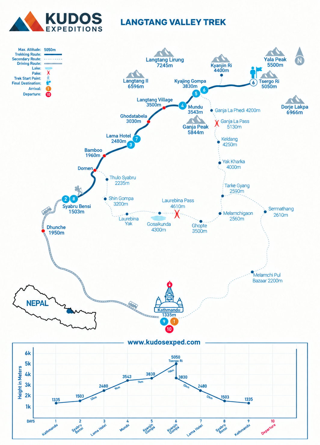
Langtang Valley Trek Trek MAP
Book Now
💬 Talk to Ang on WhatsApp
Join fixed Departure with Ang
Departing Dates
and Price
Availability
12 January, 2027 - 14 January, 2027
$ 1650
1
2 February, 2026 - 10 February, 2026
$ 1650
1
Must Know Before your Trip
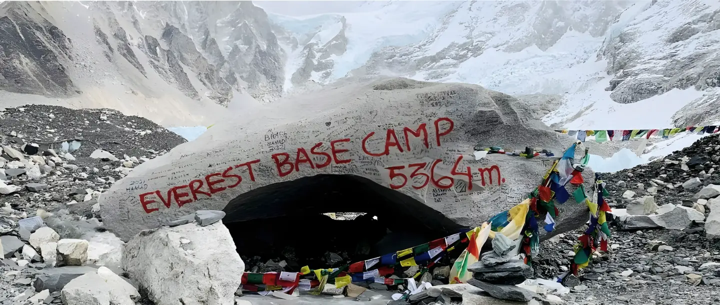
Everest Base Camp Trek: The Complete 2026 Planning Guide
Why Every High-Altitude Trekker Needs These Two Life-Saving Tools (And How to Use Them Properly)
Acclimatiation Process to make your trip successful

Why Trekkers Fail to Reach the Final Point in Nepal
Nepal Visa Information 2025: Complete Guide for Trekkers & Travelers
Gears for Langtang Valley Trek