
Annapurna Circuit Trek
There’s a moment on the Annapurna Circuit, usually somewhere between Chame and Pisang, where the valley walls pull back just enough to let Annapurna II fill the whole skyline, and most people stop walking without meaning to. I’ve watched it happen to first-timers and to trekkers on their fourth or fifth Himalayan trip. It’s the moment the trek stops being a plan on paper and becomes the thing itself.
I’m Ang Tsering Sherpa, and I’ve been guiding trekkers through this region for most of my working life. The Annapurna Circuit is, by a fair margin, the trek I get asked about most, and also the one people misunderstand the most before they arrive. They picture Everest Base Camp with a pass thrown in. What they actually get is closer to walking through five or six different countries stitched into one trail — rice terraces and waterfalls in the first days, pine forest and mani walls a few days later, then a stark, windswept high desert that looks more like Tibet or the Ladakh plateau than anything in the Kathmandu Valley. No other trek in Nepal changes this much, this fast, over a single continuous route.
This page is everything I’d tell a friend who was seriously considering the Annapurna Circuit — the route, the timing, the permits, the parts that are genuinely hard, and the parts that get exaggerated. If you read to the end, you’ll know more about this trek than most people do when they book it.
What the Annapurna Circuit Actually Is
At its core, the Annapurna Circuit is a loop trek that wraps around the entire Annapurna massif, crossing from the Marsyangdi River valley on the eastern side to the Kali Gandaki valley on the western side by going over Thorong La Pass, at 5,416 metres. That pass crossing is what most people picture when they hear “Annapurna Circuit,” but it’s really just one dramatic day inside a much longer story.
Depending on where you start and finish, and whether you add on any side trips, the full route runs somewhere between 160 and 230 kilometres. Twenty years ago, before road construction reached into the Marsyangdi valley, trekkers walked the entire thing from Besisahar, and the trip took three weeks or more. These days, most people drive the first stretch — usually to Syange, Jagat, or Dharapani — and start walking from there, which trims the trek down to somewhere between 12 and 16 days on the trail. You can go longer if you want to walk every step the old way, or shorter if you’re tight on time and willing to skip a few of the lower valley days.
A few quick facts, for anyone comparing options:
- Duration: typically 12–16 days on the trail (14–18 days total including Kathmandu)
- Total distance: roughly 160–200 km on the standard route, more with Tilicho Lake or Poon Hill added
- Highest point: Thorong La Pass, 5,416 m
- Starting elevation: around 760–840 m near Besisahar
- Trek style: teahouse/lodge trekking — no camping required
- Difficulty: strenuous, mainly due to altitude and one very long pass day
- Best seasons: March–May and September–November
- Region: Annapurna Conservation Area, Manang and Mustang districts
None of those numbers tell you what the trek feels like, though. For that, you actually have to walk it.
Why This Trek Has Stayed a Classic for Decades
Nepal has dozens of trekking routes, and plenty of them are shorter, easier, or less crowded. So why does the Annapurna Circuit keep pulling people back, year after year?
The honest answer is variety. Most Himalayan treks follow a single valley up to a viewpoint or a base camp, and then you retrace your steps back down. The Circuit doesn’t do that. You walk up one valley, cross a genuinely high mountain pass, and come down into a completely different one on the other side. The ecology, the architecture, the food, even the religion practiced in the villages shifts as you go — from the Gurung and Manangi communities of the Marsyangdi side, with their Tibetan Buddhist gompas and prayer wheels, to the Thakali villages of Mustang, where whitewashed stone houses cluster against a landscape that gets almost no rain at all.
There’s also the simple physical drama of it. You start among terraced paddy fields at under 800 metres, and less than two weeks later you’re standing at 5,416 metres, looking out over a wall of 7,000 and 8,000-metre peaks — Annapurna II, Gangapurna, Chulu, and on a clear day, distant views toward Dhaulagiri. Very few treks anywhere in the world offer that kind of elevation range and diversity of terrain inside a single, connected route.
And then there’s Muktinath. After the physical grind of the pass, arriving at one of the holiest pilgrimage sites in Nepal — sacred to both Hindus and Buddhists, with its 108 water spouts and eternal flame — gives the trek an emotional close that a lot of other routes simply don’t have. People cry at Muktinath. Not from exhaustion, or not only from exhaustion.
The Route, Stage by Stage
I’ll walk you through this the way I explain it to trekkers before we leave Kathmandu, broken into the natural chapters of the trail rather than a rigid day-by-day. Exact itineraries vary by operator and by how many acclimatization or side-trip days you build in, but the shape of the journey is fairly consistent.
Stage One: The Lower Marsyangdi Valley
Whether you start walking from Besisahar, Syange, Jagat, or Dharapani, the early days share a character. You’re moving through a warm, green river valley, past terraced farmland, waterfalls, and small Gurung villages, crossing the Marsyangdi River on long suspension bridges strung with prayer flags. The forest here is subtropical — banana trees and bamboo lower down, giving way gradually to pine and fir as the trail climbs.
This section gets underrated. Trekkers are often eager to reach the “real mountains,” so they treat these first days as a formality. But it’s here that you settle into trekking rhythm, get your legs and lungs working properly, and start noticing how the architecture changes from village to village — flat mud roofs lower down, steeper wooden or stone roofs as you climb into snow country.
Stage Two: Chame to Pisang, and On to Manang
Past Chame, the district headquarters of Manang and a good spot to restock or grab a coffee, the valley narrows and the trail runs beneath a striking rock formation locals call Paungda Danda — a curved wall of pale granite that looks almost carved. From here you have a choice: the lower trail through Lower Pisang, which is faster and gentler, or the upper trail through Upper Pisang, Ghyaru, and Ngawal, which climbs higher along the ridge and delivers, in my opinion, the best sustained mountain views on the entire eastern half of the circuit. It costs you more elevation gain and a longer day, but if your legs and lungs are cooperating, I almost always steer trekkers onto the upper route.
Both paths converge before Manang, at 3,540 metres, which functions as the unofficial capital of the trek’s midpoint. It’s a proper village — shops, bakeries, a cinema showing mountain documentaries, even a small hospital clinic run seasonally by the Himalayan Rescue Association. Most itineraries build in a full rest day here, and that’s not a formality either.
Stage Three: Acclimatization in Manang — the Day People Underrate
I tell every trekker the same thing about the Manang rest day: it’s not a lazy day, and it’s not optional if you want a comfortable pass crossing. You’re at 3,540 metres, and the trek’s high point sits nearly 1,900 metres above you. Sleeping at altitude, and giving your body a chance to adapt before pushing higher, is the single biggest factor in how the rest of the trek feels.
That doesn’t mean sitting in a teahouse all day. The better move is a “climb high, sleep low” day hike — up to Gangapurna Lake, or higher still toward the Ice Lake or Praken Gompa above Braga, and then back down to sleep in Manang. Trekkers who do an active acclimatization day almost always report an easier time above 4,000 metres than those who simply rest.
Stage Four: Into the High Country — Yak Kharka and Thorong Phedi
Past Manang, the trail leaves the last real trees behind and opens into yak pasture and alpine scrub. You’ll pass through Yak Kharka at 4,050 metres, and then climb to Thorong Phedi at 4,540 metres (some trekkers push a further 300 vertical metres to High Camp, though I generally advise against it — the extra elevation before the pass often costs people more sleep quality than it saves in walking time the next morning).
These aren’t technically hard walking days. The trail is well-defined, the gradient isn’t extreme, and there’s no scrambling or exposure involved. What makes them feel difficult is the altitude itself. The air is noticeably thinner, appetite tends to drop, and sleep becomes lighter and more broken. The advice I give here is unglamorous but it works: walk slower than feels natural, drink more water than you think you need, eat even when you’re not hungry, and don’t compare your pace to anyone else on the trail.
Stage Five: Thorong La Pass — The Day Everything Builds Toward
This is it — the highest point most trekkers will ever stand on foot. At 5,416 metres, Thorong La is among the highest trekking passes used regularly in the world, and crossing it is, without question, the single most physically demanding day of the trek.
Most groups leave Thorong Phedi or High Camp in the dark, somewhere between 3:30 and 5:00 a.m., aiming to summit the pass before mid-morning. There’s a good reason for the early start beyond tradition: wind on the pass tends to pick up sharply in the afternoon, sometimes to genuinely dangerous speeds, and starting early gives you a buffer if the pace turns out slower than planned. The climb itself takes anywhere from four to six hours depending on conditions, snow cover, and how your body is handling the altitude.
At the top, weather permitting, you get an enormous panorama — Annapurna I, Gangapurna, the Chulu peaks, and on clear days a glimpse toward Dhaulagiri, one of only two places on earth where two 8,000-metre peaks are visible from the same viewpoint at a walkable pass. Most people don’t linger long at the summit; the cold and the altitude discourage it. Then comes the descent — a steep drop of around 1,600 metres in a single day down to Muktinath, one of the fastest and hardest-on-the-knees descents in Himalayan trekking.
Stage Six: Muktinath and the Turn Into Mustang
Arriving in Muktinath, at roughly 3,710 metres, marks a real shift — not just in elevation but in atmosphere. This is one of Nepal’s most significant pilgrimage sites, held sacred by both Hindus and Buddhists, centered on a temple where 108 stone water spouts and a natural eternal flame draw pilgrims from across the subcontinent. After days of glacier, scree, and thin air, arriving somewhere with this much history and devotion tends to land differently than any viewpoint could.
From here the trek continues into the Kali Gandaki valley — a landscape almost nobody expects. This is Nepal’s rain shadow country, dry, wind-carved, and visually closer to the high plateau of Tibet than to anywhere most people associate with Nepal trekking. Kagbeni, with its medieval mud-brick alleys and gateway-to-Upper-Mustang feel, and Jomsom, the region’s administrative hub, are the main stops. If time allows, Marpha is worth the detour — a whitewashed Thakali village famous across Nepal for its apple orchards and locally distilled apple brandy.
Stage Seven: How You Choose to Finish
This is where the modern Annapurna Circuit branches into real options, and it’s worth deciding in advance which version fits you.
Some trekkers end the on-foot portion in Jomsom or Muktinath and fly or drive out toward Pokhara, which shortens the trip considerably. Others continue on foot down the Kali Gandaki, through Tatopani — worth a stop for its natural hot springs after two weeks of trail grime — and up again to Ghorepani for the classic Poon Hill sunrise, before finishing in Nayapul and driving to Pokhara. That option adds two to three days but gives you one of Nepal’s most famous sunrise viewpoints as a closing act, with a 360-degree wall of Annapurna, Dhaulagiri, and Machhapuchhre catching first light.
There’s also the Tilicho Lake side trip, usually branching off before or around Manang. At close to 4,919 metres, Tilicho is one of the highest lakes of its size anywhere in the world, and the trail out to it is genuinely wild — narrow, exposed in sections, and best attempted with good weather and a guide who knows current trail conditions. It adds two to three days but rewards you with a landscape that feels far more remote than the main circuit.
None of these choices is objectively “better.” The right version depends on your time, your fitness, and what you actually want out of the trip — pure mountain scenery, cultural depth, a physical challenge, or some balance of all three.
Roads and Route Changes — What’s Actually Different Today
If you’ve read older trip reports or guidebooks, you may have come across complaints about road construction on the Annapurna Circuit. It’s a fair concern, and I’d rather address it directly than pretend it doesn’t exist. Over the past fifteen years, jeep roads have pushed into sections of both the Marsyangdi and Kali Gandaki valleys, and on some stretches, trekkers do share the trail with vehicle traffic, at least seasonally.
The trekking community’s response to this has been the NATT network — Natural Annapurna Trekking Trails — a set of alternative paths, mostly on the opposite side of the river or higher on the ridgeline, built specifically to route trekkers away from the road. A good guide will know exactly where these alternatives exist and will use them by default rather than walking the road out of habit. In practice, this means the “road problem” affects the Annapurna Circuit far less today than it did a decade ago, provided your itinerary and your guide actually prioritize the trail-based routing.
How Hard Is It, Really?
I get asked this constantly, and I try to give a straight answer rather than a marketing one. The Annapurna Circuit is not technical. You don’t need climbing experience, ropes, or crampons on the standard route. There’s no scrambling, no exposed ledges you need prior experience to handle.
What makes it hard is altitude and duration. You’re walking for twelve to sixteen consecutive days, several of them at elevations where the air holds noticeably less oxygen than your body is used to, and one of them — pass day — involves a pre-dawn start, four to six hours of steady climbing to over 5,400 metres, followed immediately by a steep multi-hour descent. That combination is why most trekking operators, including us, grade it as strenuous or challenging rather than moderate.
The good news is that success on this trek is much more about consistency and patience than raw athletic ability. I’ve guided plenty of “average” hikers who did fine because they paced themselves sensibly, drank enough water, and respected the acclimatization schedule — and I’ve seen very fit, competitive trekkers struggle because they pushed too hard, too fast, and paid for it above 4,000 metres. If you can comfortably walk five to seven hours a day, several days in a row, on hilly terrain, and you’re willing to go slowly at altitude even when your body feels capable of more, you’re a realistic candidate for this trek.
Best Time of Year to Go
There isn’t one single “correct” season for the Annapurna Circuit. It depends on what matters most to you — clear mountain views, warmer nights, fewer people on the trail, or the safest possible pass conditions.
Autumn, September through November, is the classic choice, and for good reason. Post-monsoon skies tend to be clear and stable, trail conditions are generally good, and the mountain views are about as sharp as they get anywhere in the Himalaya. The trade-off is popularity — October and early November are the busiest weeks on the circuit, and teahouses around Manang, Thorong Phedi, and High Camp can fill up quickly during peak weeks, so booking ahead matters more here than in any other season.
Spring, March through May, runs a close second. Lower elevations bloom with rhododendron forest in March and April, which the autumn season simply doesn’t offer, and daytime temperatures are usually milder. The trade-off is a slightly higher chance of afternoon cloud buildup, particularly as you move into May, and some residual snow on the pass itself in early spring.
Winter, December through February, is for a smaller, more experienced crowd. The trails are quiet, the air is often crystal clear, and if you’re comfortable with genuine cold, it can be a spectacular time to trek. But Thorong La can and does close for days at a time after heavy snowfall, and conditions above Manang turn serious quickly. I don’t recommend winter for first-time Himalayan trekkers unless you’ve built in generous buffer days and come prepared for real winter mountain conditions.
Monsoon, June through September, is where the Annapurna Circuit actually has an advantage over most other Nepal treks. Because the northern half of the route — Manang and Mustang — sits in a rain shadow, it stays comparatively dry even while the rest of the country is soaked. It’s not the season I’d choose for a first attempt, since cloud cover can obscure the big views and the lower valleys still see rain, but with a knowledgeable guide it’s a legitimate option for trekkers chasing solitude.
Where You’ll Sleep and What You’ll Eat
The Annapurna Circuit is a teahouse trek from start to finish, which means you’re staying in family-run lodges rather than camping, and it’s one of the more comfortable long treks in Nepal in that respect. Rooms are simple — usually twin-share, with a mattress, pillow, and blanket, though most trekkers still bring a sleeping bag rated for below-freezing temperatures for the higher villages. Bathrooms are often attached lower down the valley and increasingly shared as you climb toward Manang and beyond. Dining rooms are typically heated in the evenings with a wood or dung-fired stove; bedrooms almost never are, so expect the cold once you leave the dining hall.
Food is better and more varied than a lot of first-timers expect. Dal bhat — rice, lentil soup, and vegetable curry, often with unlimited refills — is the trekker’s staple for good reason: it’s filling, it’s what the kitchen staff eat too, and the ingredients are typically fresher than anything else on the menu at altitude. Beyond that, most teahouses serve noodle soups, fried rice, momos, pasta, pancakes, and eggs cooked however you like them. Vegetarian options are everywhere, since much of the local population eats a largely vegetarian diet at these elevations.
A few practical notes I give every group: eat properly even when your appetite drops at altitude, because your body is burning far more calories than usual just to keep warm and keep moving. Favor warm food over cold on the higher, colder nights. And on pass day itself, stick to simple carbohydrates your stomach already knows it tolerates — this is not the day to experiment with something new on the menu.
Permits and Paperwork
You cannot legally trek the Annapurna Circuit without the correct permits, and the rules have tightened in recent years, so it’s worth understanding exactly what’s required.
Annapurna Conservation Area Permit (ACAP): the entire route runs through protected conservation area, so this entry permit is mandatory. As of the current fee structure, it costs NPR 3,000 for foreign nationals and NPR 1,000 for SAARC nationals, with children under 10 exempt. You’re expected to carry it with you throughout the trip, since it’s checked at multiple entry points along the trail.
TIMS Card and licensed guide requirement: under Nepal’s revised TIMS provision, effective since March 2023, a number of protected trekking routes — the Annapurna Circuit explicitly among them — now require trekkers to be accompanied by a licensed trekking guide and to carry a TIMS card issued through a registered trekking agency. The TIMS fee itself is NPR 2,000 for non-SAARC nationals and NPR 1,000 for SAARC nationals. This isn’t a loophole-friendly rule; Nepal Tourism Board has been clear that trekking without a licensed guide on routes where this applies is treated as a punishable offense, not just an inconvenience.
Restricted-area extensions: if you’re tempted to extend into genuinely restricted zones, such as certain Nar-Phu side valleys off the Manang side of the circuit, those require a separate restricted-area permit processed through the Department of Immigration, with its own fee structure and minimum group requirements. Not something to plan casually — if you want to add one of these extensions, build it into your itinerary from the start.
Staying Safe — Altitude Is the Real Challenge Here
I’ll be direct about this because it matters more than almost anything else on the trip: altitude sickness is the single biggest safety issue on the Annapurna Circuit, more than weather, more than terrain, more than anything else. Thorong La sits at 5,416 metres, and the days leading up to it involve sleeping progressively higher, which is exactly the pattern that puts stress on the body.
A few habits genuinely reduce risk, and I repeat them constantly on the trail:
Build in real acclimatization time, particularly the rest day in Manang, and use it actively rather than just sitting still. Walk at what locals call “Nepali flat” pace — slower than feels necessary, especially above 3,500 metres. Drink far more water than you think you need; dehydration compounds altitude symptoms. Eat consistently, even without appetite. And the one rule that overrides everything else: never push through worsening symptoms. A mild headache that’s improving with rest and fluids is normal. A headache that’s getting worse, especially paired with nausea, dizziness, or a loss of coordination, means descend — immediately, not after “just a bit further.”
Weather is the second major factor. In colder months, Thorong La can close for days after heavy snowfall, which is exactly why flexible itineraries with buffer days matter, particularly if you’re trekking outside the peak autumn window. And on pass day specifically, starting early isn’t a tradition for its own sake — afternoon winds on the pass can build to genuinely dangerous speeds, and an early start is your simplest protection against getting caught out in them.
Finally, travel insurance that specifically covers high-altitude trekking and helicopter evacuation is non-negotiable on this route. It’s not included in most trek packages, ours included, and it’s the one piece of paperwork you don’t want to discover you’re missing after something’s already gone wrong.
Packing for a Trek That Crosses Six Climate Zones
Because the Annapurna Circuit moves through such a wide elevation and climate range, packing for it is genuinely different from packing for a single-valley trek. You’ll want a proper layering system — a moisture-wicking base layer, an insulating mid-layer like fleece or light down, and a waterproof, windproof outer shell, since conditions can shift fast, especially near the pass. A sleeping bag rated to at least -15°C is worth the extra pack weight once you’re above Manang, even if the teahouse provides blankets. Good broken-in trekking boots matter more here than on almost any other Nepal trek, given the sheer number of consecutive walking days. Trekking poles help significantly on the steep Thorong La descent, where your knees take the brunt of nearly 1,600 metres of elevation loss in a single day. And don’t underestimate sun protection at altitude — UV exposure near 5,000 metres is intense even on cool days, so good sunglasses (ideally with side coverage for the pass crossing) and high-SPF sunscreen belong near the top of your bag, not buried at the bottom.
Trekking the Circuit With a Local Guide
I won’t pretend this section is neutral, because it isn’t — I run treks in this region for a living, and I believe strongly in how I run them. But even setting that aside, there are practical reasons a licensed local guide changes the experience on the Annapurna Circuit specifically, beyond the fact that current regulations now require one on this route.
Route knowledge matters more here than on most Nepal treks, precisely because of the road development discussed earlier. Knowing which NATT alternative to take at a given junction, which teahouses genuinely have space during a busy autumn week versus which ones will turn you away at 4pm, and how a specific day’s weather pattern at Thorong Phedi is shaping up before you commit to a High Camp push — none of that comes from a guidebook or an app. It comes from walking this exact route dozens of times, across every season, and staying current on how conditions change year to year.
On our fixed departures and private treks, I guide personally, alongside an assistant Sherpa guide for every five trekkers and porters at roughly one for every two, so nobody is carrying a full pack over Thorong La. Permits, TIMS documentation, teahouse accommodation, and daily meals are all arranged in advance, which matters more during peak autumn weeks than people expect — by the time you’re standing at the door of a teahouse in Thorong Phedi at 4pm in late October, you want your room already secured, not still being negotiated.
Frequently Asked Questions
How difficult is the Annapurna Circuit Trek?
It is a moderate-to-challenging trek, primarily due to the crossing of Thorong La Pass at 5,416m (17,769 ft). With Ang Tsering Sherpa guiding, we ensure proper acclimatization days in Manang before the pass, making it safe and achievable for fit trekkers.
How much of the trail is on a motorable road?
While road construction has changed the classic route, Ang expertly navigates the New Annapurna Trekking Trails (NATT). These alternative paths bypass the dusty jeep tracks, keeping you immersed in the authentic Himalayan wilderness.
When is the best time to hike the Annapurna Circuit?
The ideal windows are the pre-monsoon spring (March–May) and post-monsoon autumn (September–November). These months offer the most stable weather and clear skies for safely crossing the high passes.
What is the risk of altitude sickness on the Annapurna Circuit?
Because the trek exceeds 5,000 meters, altitude sickness is a real risk. We counter this by ‘climbing high and sleeping low.’ Ang monitors your oxygen levels daily and carries a comprehensive medical kit to address any symptoms immediately.
Are there charging stations and WiFi on the route?
Yes, the Annapurna Circuit is highly developed. Most teahouses offer WiFi and charging stations for a small extra fee. Ang ensures we book the best lodges so you can stay comfortable and connected.
Planning Your Own Annapurna Circuit
There’s no single “right” way to do this trek. Some people want the full classic experience, walking every valley stage and finishing over Poon Hill. Others want the core route with Tilicho Lake added for a taste of somewhere genuinely remote. Some just want to reach Muktinath, stand at Thorong La once in their life, and fly out from Jomsom feeling like they’ve done something real without needing three full weeks away from work.
Whichever version fits your time and your fitness, the fundamentals stay the same: respect the acclimatization schedule, pace yourself honestly rather than competitively, choose your season based on what you actually value most, and trek with people who know the current state of this route — because between the weather, the road development, and the pass itself, “current” is a word that actually matters here.
If you’d like help building an itinerary around your dates, fitness level, and priorities, get in touch and we’ll put one together — whether that’s joining one of our fixed departures or arranging a private trek guided personally start to finish.
Standard Annapurna Circuit Trek Itinerary
Day 1
Arrival in Kathmandu
My team meets you at the airport with a private vehicle and gets you to your hotel. Over tea, we'll walk through the trip ahead and I'll get a first read on your fitness so we can pace things right.Day 2
Trek Preparation Day in Kathmandu
We sort your ACAP permit and TIMS card, check your gear against the packing list, and pick up anything missing in Thamel. First-timers can also fit in a quick visit to Swayambhunath or Pashupatinath.Day 3
Drive from Kathmandu to Besisahar (760m)
We follow the Prithvi Highway west along the Trishuli River into Lamjung district — a long but scenic drive past terraced fields and market towns. Besisahar is the classic gateway to the circuit, and your last reliable ATM for a while.Day 4
Drive from Besisahar to Taal (1,700m)
We switch to a 4WD jeep and follow the Marsyangdi River as the valley narrows. Taal sits right where the road ends and the trail begins — a quiet spot before the walking starts tomorrow.Day 5
Trek from Taal to Dharapani (1,860m)
An easy, scenic start — forest, waterfalls, and a few suspension bridges along the Marsyangdi. Somewhere along here you'll cross into the Annapurna Conservation Area, and the villages start to feel more Tibetan.Day 6
Trek from Dharapani to Chame (2,710m)
The trail climbs through oak and pine as the valley narrows into a gorge. Chame is Manang district's headquarters — bakeries, shops, a hot spring, and your first clear view of Annapurna II.Day 7
Trek from Chame to Upper Pisang (3,300m)
One of my favorite days on the circuit. You'll cross more bridges and pass beneath Paungda Danda's huge curved rock face before reaching Upper Pisang, a great spot for sunrise over Annapurna II.Day 8
Trek from Pisang to Manang via Ghyaru and Ngawal (3,540m)
I take groups on the higher route through Ghyaru and Ngawal — steeper, but it opens up the biggest panorama of the trek (Annapurna II, III, IV, Gangapurna, Tilicho Peak) and helps acclimatization along the way.Day 9
Acclimatization Day in Manang (3,540m)
The smartest day of the trek, not the laziest. We hike up toward Ice Lake or the Gangapurna viewpoint, then sleep back down in Manang — "climb high, sleep low" in practice.Day 10
Trek from Manang to Yak Kharka (4,050m)
The trail leaves the forest behind for good — alpine grass, scrub juniper, and often yaks grazing nearby. Short distance, but altitude means we keep the pace unhurried.Day 11
Trek from Yak Kharka to Thorong Phedi (4,540m)
A short, deliberately easy day to save energy for tomorrow. Eat well, sort your gear, and get to bed early — pass day starts in the dark.Day 12
Cross Thorong La Pass to Muktinath (5,416m → 3,800m)
The big one. We start around 4–5 AM to clear the pass before the afternoon winds — slow, steady steps to 5,416m, then a long 1,600m descent into Muktinath, a sacred site for Hindus and Buddhists alike.Day 13
Drive from Muktinath to Pokhara (via Jomsom)
A well-earned late start, then a drive through the stark Kali Gandaki gorge via Kagbeni and Jomsom. Pokhara's lakeside warmth is a nice contrast by evening.Day 14
Fly from Pokhara to Kathmandu
A short 25-minute mountain flight back to Kathmandu. The day is free to rest or explore, and in the evening we'll close things out with a farewell dinner.Day 15
Contingency Day in Kathmandu
Built in on purpose in case mountain weather causes delays earlier in the trip. If not needed, it's a free day for extra sightseeing or rest before you fly out.Day 16
Final Departure
Transfer to Tribhuvan International Airport for your onward flight. Circuit complete — and if this is your first Himalayan trek, I doubt it'll be your last.Things Included in Trip cost

Transportation
-
Airport pick-up in Kathmandu by private vehicle
-
Airport drop-off in Kathmandu by private vehicle
-
Drive from Kathmandu to Besisahar
-
Drive from Besisahar to Taal
-
Drive from Muktinath to Pokhara
-
Flight from Pokhara to Kathmandu

Accommodation
- Teahouse accommodation during the entire trek

Meals
-
Daily tea, breakfast, lunch, and dinner during trekking days
-
Afternoon tea and biscuits at around 4:00 PM after reaching the teahouse/camp
-
Seasonal fresh fruits after dinner during the trek
- Farewell dinner in Kathmandu on the last evening

Human Resource
-
Experienced English-speaking guide personally guided by ANG
-
Assistant Sherpa guide (1 assistant for every 5 trekkers)
-
Porters as required (typically 1 porter for every 2 trekkers)
-
All staff wages, meals, accommodation, and insurance for Nepali crew

Documentations
-
Annapurna Conservation Permit
-
TIMS (Trekkers’ Information Management System) card
- NTNC
- All government taxes and local service taxes

Trek Support Gears
- Company-provided trekking duffle bag
Things Not Included in Trip cost

Visa & Travel Documents
Nepal visa fee (please bring two passport-size photos and cash in USD denomination)

International Travel
International airfare to and from Nepal
Excess baggage charges for domestic flights

Personal Insurance (Mandatory)
Personal travel insurance
High-altitude rescue and helicopter evacuation insurance
Meals in Kathmandu
Lunch and dinner in Kathmandu (except farewell dinner)
Meals in Kathmandu if you return early from the trek
Extra Hotel Nights in Kathmandu
Extra nights in Kathmandu due to early arrival, late departure, or early return from the trek for any reason
Extra nights caused by flight delays or itinerary changes outside the scheduled program

Personal Expenses
Extended activities and extra destinations not mentioned in the itinerary
Cold drinks during the trek (mineral water, soft drinks, beer, bar bills, bakery items, machine coffee)
Hot showers during the trek
Battery charging fees for electronic devices
Wi-Fi/internet charges during the trek

Tips and Gratitude
Tips for guides, assistant guides, and porters

Emergency Cost
- Helicopter evacuation in case of emergency (covered by your insurance, not by the package)
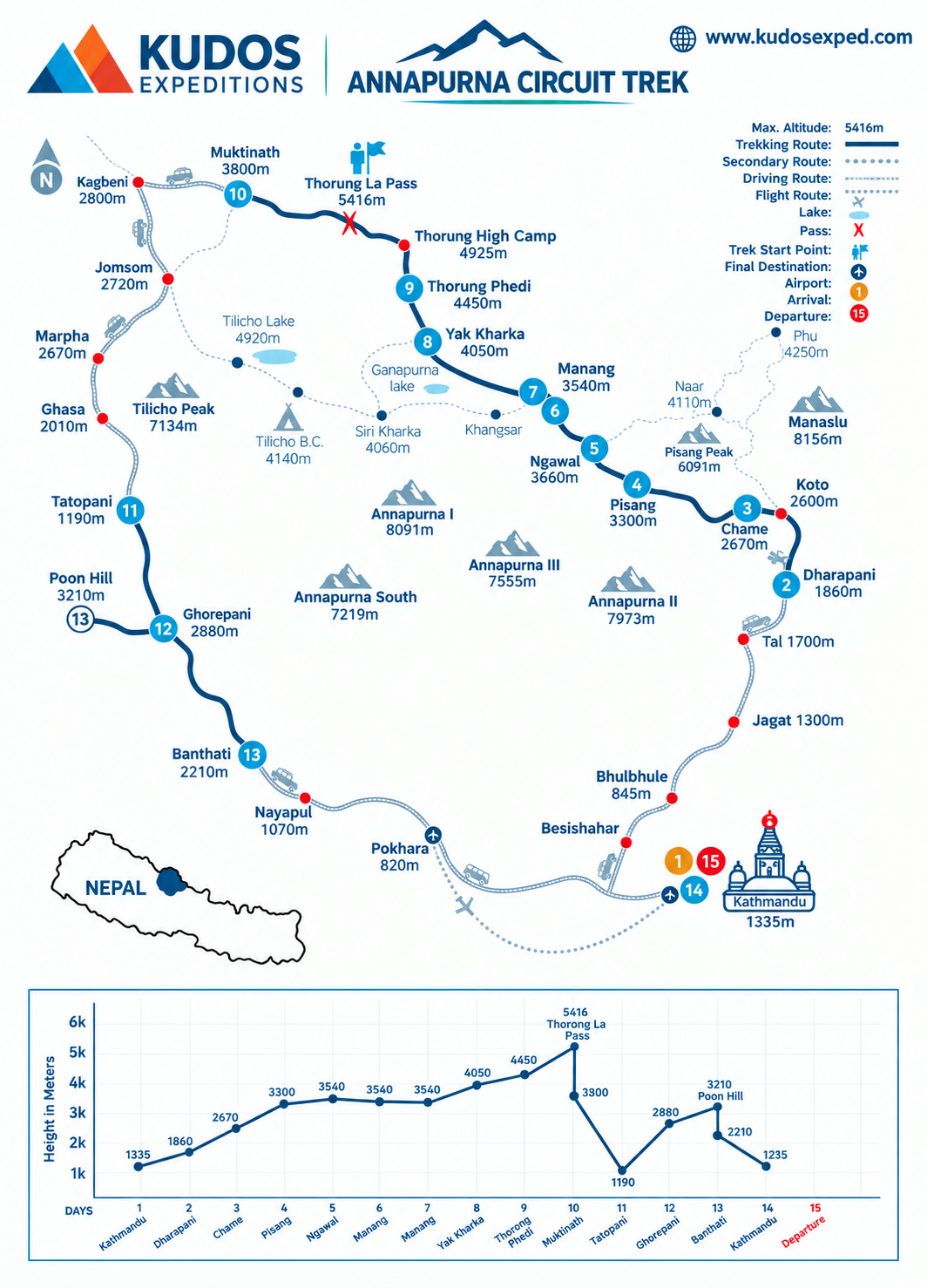
Annapurna Circuit Trek Trek MAP
Book Now
Join fixed Departure with Ang
Departing Dates
and Price
Availability
1 September, 2027 - 15 September, 2027
$ 1700
1
Must Know Before your Trip
Everest Base Camp Trek: The Complete 2026 Planning Guide

Why Every High-Altitude Trekker Needs These Two Life-Saving Tools (And How to Use Them Properly)

Acclimatiation Process to make your trip successful
