
Mera Peak Climbing

Trip Difficulty: Moderate

Trip Days:22

Max Elevation: 6470m

Daily Activity: 6-7 hours Trek

Trip Starts: Lukla

Trip Ends: Lukla
A remote Hinku Valley approach to one of Nepal’s highest trekking peaks
Mera Peak is often introduced as Nepal’s highest trekking peak. That description is useful, but incomplete. The mountain is high enough to make every decision matter. The summit reaches 6,470 metres, the approach passes through remote valleys and the final ascent involves glacier travel, crampons, rope systems and a pre-dawn start from high camp.
The normal journey begins with a flight to Lukla, then moves away from the busiest Everest Base Camp trail. Instead of continuing toward Namche Bazaar, the route climbs through forest and crosses the Zatrwa La into the Hinku Valley. Villages become smaller, mobile reception fades and the landscape feels progressively less connected to the main Khumbu corridor.
This 22-day itinerary gives the mountain the time it deserves. It includes a controlled approach, staged altitude gain, an acclimatization and skills day at Khare, a high camp, a summit attempt and weather contingency. Short itineraries may appear efficient, but the human body cannot be hurried into performing well above 6,000 metres.
Mera Peak is frequently called non-technical because the standard glacier route does not usually involve sustained steep rock or ice climbing. That label should never be confused with easy. Climbers must walk roped on glaciated terrain, use crampons efficiently, manage severe cold and maintain concentration through a long ascent and descent.
The mountain has several named summits. Mera North is commonly listed at 6,470 metres and is the main objective described on this page. Mera Central is often given as approximately 6,461 metres, while Mera South is significantly lower. Commercial descriptions have not always been consistent about which point was reached, so the summit policy should be explained clearly before booking.
For a well-prepared trekker, Mera can be an excellent first 6,000-metre climb. It rewards endurance, patience and reliable basic technique more than aggressive speed. It also provides a broad Himalayan panorama that may include Everest, Lhotse, Makalu, Cho Oyu and Kangchenjunga in exceptionally clear conditions.
Kudos Expeditions treats the trip as a complete climbing program rather than a fast trek with a summit morning attached. Guides monitor acclimatization, teach the required equipment systems and set conservative turnaround rules. The summit is important, but the expedition is only successful when the team returns safely.
Mera Peak Expedition at a glance
| Trip detail | Information |
| Mountain | Mera Peak / standard objective: Mera North |
| Official working altitude | 6,470 m / 21,227 ft |
| Region | Hinku Valley, eastern Nepal |
| Trip duration | 22 days |
| Difficulty | Challenging high-altitude glacier climb |
| Starting and finishing point | Lukla |
| Typical summit-day duration | 8–12 hours or more |
| Accommodation | Hotels, teahouses and tented high camp |
| Main acclimatization base | Khare |
| Principal high camp | Approximately 5,780 m |
| Climbing terrain | Snow, glacier and variable crevasse terrain |
| Main equipment | Crampons, harness, ice axe, helmet and rope systems |
| Best-known seasons | Spring and autumn |
| Core permits | Mera climbing permit, TIMS and route-dependent protected-area or local permits |
Why Mera Peak is different
The standard Mera approach feels separate from the commercial centre of the Everest region. Once the trail leaves the Lukla area and crosses toward the Hinku Valley, the number of trekkers drops. Forest, ridges and isolated lodge settlements replace the busy sequence of Namche, Tengboche and Dingboche.
The mountain is also high enough to provide a genuine expedition rhythm. At Khare, trekking equipment is reorganised and climbing systems become the focus. High camp is cold and exposed. Summit day begins in darkness, and the pace above 6,000 metres is governed by breathing rather than ambition.
Technically, the normal route is often less steep than Island Peak or Lobuche East. Physically, the greater altitude can make Mera harder. Climbers who underestimate the summit because of the word non-technical often discover that oxygen shortage, cold and duration are the true obstacles.
Mera also works as a progression peak. It gives strong trekkers experience with glacier travel, rope-team movement, crampons and a summit above 6,000 metres. Those skills can support future plans for Lobuche East, Island Peak, Ama Dablam or higher expedition peaks, although each of those objectives demands separate preparation.
Expedition highlights
- Climb to the 6,470-metre summit of Mera Peak.
- Leave the crowded Everest Base Camp corridor for the quieter Hinku Valley.
- Cross the Zatrwa La and trek through rhododendron, bamboo and alpine terrain.
- Acclimatize and practise climbing systems at Khare.
- Sleep at Mera High Camp at approximately 5,780 metres.
- Travel roped across glacier terrain under guide supervision.
- Use crampons, an ice axe, harness and fixed or running rope systems.
- See major Himalayan peaks from one of Nepal’s broadest high viewpoints.
- Gain practical 6,000-metre experience without sustained technical rock climbing.
- Complete a 22-day itinerary with meaningful summit contingency.
Understanding the Mera Peak Route
The Hinku Valley approach
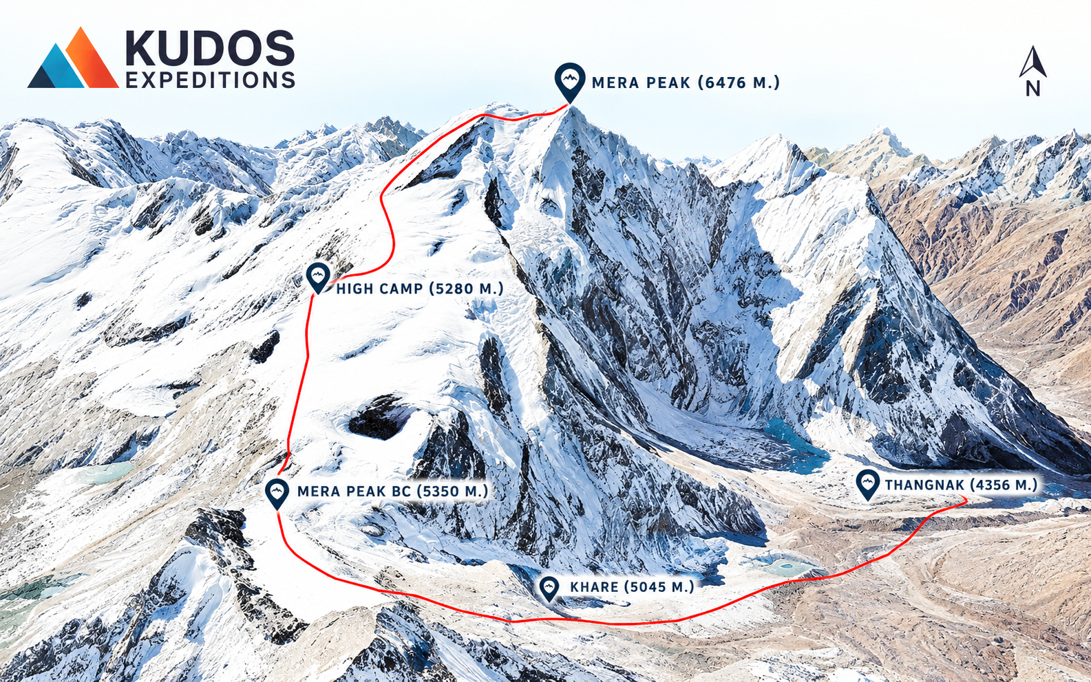
The classic route reaches Mera from the west through Lukla, Chutanga and the Zatrwa La. This approach provides a compact connection from the Khumbu airstrip to the Hinku Valley, but the pass arrives early enough that acclimatization must be planned carefully.
An alternative southern approach enters through lower villages and can create a more gradual altitude profile, although it requires additional road or trekking logistics. Private programs may use that route when time permits.
Beyond Kothe, the valley becomes increasingly alpine. Thaknak provides a useful acclimatization base, while Khare marks the practical beginning of the climb.
Mera North, Mera Central and Mera South
Mera is a broad mountain with several named summits. Nepal Mountaineering Association currently lists Mera Peak at 6,470 metres. That figure is commonly associated with Mera North and is the altitude used by the live Kudos product.
Mera Central is usually listed at approximately 6,461 metres, and Mera South is around 6,065 metres. Older commercial records and GPS devices have produced inconsistent summit claims.
The booking page should state the exact objective, the normal route used and the operator’s policy when conditions prevent access to the highest recognised point. Precision here protects client expectations and strengthens credibility.
The glacier and upper route
From Khare, the route climbs toward the Mera Glacier and Mera La. Rope use depends on crevasse conditions and the guide’s judgement. Even gentle-looking glacier terrain requires disciplined spacing and communication.
Mera High Camp is commonly positioned on or near a rocky outcrop at approximately 5,780 metres. The location can be affected by snow accumulation, wind and available tent platforms.
Above high camp, the route crosses broad snow slopes toward the summit. In some seasons, the final rise is straightforward. In others, a fixed line may be required where the slope steepens or a bergschrund complicates access.
What summit day is actually like
The alarm sounds while the camp is still dark. Eating can be difficult at nearly 5,800 metres, yet starting without fuel creates a larger problem later.
Climbers dress carefully, attach crampons, rope together and leave under headlamps. The pace is slow from the beginning. Above 6,000 metres, a few steps may be followed by several breaths.
The route can feel technically calm, but altitude magnifies small inefficiencies. Poor glove management, loose crampons or a tangled rope consume energy that cannot be replaced easily.
The summit is only halfway. The descent often occurs after sunrise when snow begins to soften and attention starts to decline. Guides protect the return through fixed turnaround times and controlled rope movement.
Difficulty, Experience and Fitness
How difficult is Mera Peak?
Mera Peak is physically challenging and technically introductory to moderate on the normal route. The greatest difficulty is the combination of altitude, cold, duration and accumulated fatigue.
The approach includes the Zatrwa La, multiple trekking days and several nights above 4,000 metres. The summit climb starts from a high camp where sleep is limited and hydration requires deliberate effort.
Glacier conditions are not fixed. Crevasses, hard ice, new snow and wind can increase technical seriousness. A route that was straightforward for one group may be different several weeks later.
Recommended previous experience
- Several multi-day treks with sustained ascent and descent.
- Previous experience above 4,500 metres, preferably above 5,000 metres.
- Basic familiarity with crampons, an ice axe and a climbing harness.
- Comfort following rope-team instructions and conservative turnaround decisions.
- Ability to walk 6–8 hours on consecutive days with a loaded daypack.
Can a first-time climber join?
A strong trekker may join Mera as a first mountaineering objective when the itinerary includes genuine training and the participant arrives fit. Previous instruction before Nepal is still preferable. A one-day lesson at Khare should refresh skills, not replace all prior preparation.
Acclimatization and Altitude Safety
Mera’s altitude is the defining challenge. At 6,470 metres, the body operates with much less available oxygen than at sea level. Acclimatization cannot remove that effect, but it can make performance safer and more predictable.
The itinerary uses staged nights at Chutanga, Thuli Kharka, Thaknak and Khare, followed by Mera La and high camp. Active acclimatization days allow controlled height gain while retaining lower sleeping elevations.
Symptoms of acute mountain sickness include headache, nausea, dizziness, unusual fatigue, poor appetite and disturbed sleep. Worsening symptoms require a halt in ascent.
Confusion, inability to walk in a straight line, severe breathlessness at rest or a wet cough may indicate a life-threatening condition. Immediate descent and emergency support take priority over the summit.
Fitness does not protect a climber from altitude illness. In some cases, highly trained participants create risk by moving too quickly. The guide’s slow pace is part of the safety system.
Training for Mera Peak
A 10- to 12-week preparation plan
- One long hill hike each week with a 7–10 kg pack.
- Two steady cardiovascular sessions using running, cycling, rowing or incline walking.
- Two strength sessions focused on step-ups, squats, lunges, calf raises, posterior-chain strength and core stability.
- One shorter recovery walk or mobility session.
- At least one complete rest day.
Train for cumulative fatigue
Single-day fitness is not enough. Include back-to-back hiking days during the final month so the body learns to work before it has fully recovered.
Practise climbing equipment
Before departure, practise fitting crampons, walking without catching points, carrying an ice axe, clipping into a rope and wearing a harness over multiple layers. Skills should remain functional while wearing thick gloves.
Do not overtrain at the end
Reduce volume during the final week. Arriving tired or injured is more damaging than missing one last workout.
Best Time to Climb Mera Peak
Spring: March to May
Spring is one of the main climbing seasons. Temperatures gradually become less severe, and settled periods can provide good summit conditions. New snow, afternoon cloud and warming-related instability still require attention.
Autumn: September to November
Autumn commonly brings clear post-monsoon air and strong visibility. Nights can be colder than in spring, and upper slopes may be hard or icy.
Winter
Winter climbing is possible for experienced teams but involves severe cold, shorter daylight and increased logistical difficulty. It is not the standard recommendation for first-time 6,000-metre climbers.
Monsoon
Cloud, rain, unstable flights and heavy snow at altitude make the monsoon a specialist season. Most commercial departures avoid it.
Accommodation, Food and Expedition Life
Teahouses
The approach uses simple mountain lodges. Rooms normally contain twin beds and are unheated. Shared bathrooms are common, and charging, showers or Wi-Fi may cost extra.
Tented climbing camps
Mera La and high camp are practical tented sites. Space is limited, water must be carried or melted and meals are designed around energy and digestion rather than variety.
Food
Teahouses commonly serve dal bhat, rice, noodles, potatoes, soup, pasta, eggs, porridge and bread. At high altitude, familiar carbohydrate-rich food is usually more useful than heavy or unfamiliar meals.
Hydration
Dry air and increased breathing accelerate fluid loss. Carry insulated bottles and begin summit day well hydrated. Water may freeze quickly at high camp.
Permits, Flights and Insurance
Climbing permit
Mera Peak is managed through the Nepal Mountaineering Association trekking-peak permit system. NMA currently lists foreign-climber service charges of USD 350 in spring and USD 175 in autumn, winter and summer. Fees can change and should be reconfirmed before publication or invoicing.
TIMS and route permissions
Nepal Tourism Board lists the Mera Peak Trek among routes requiring a licensed guide and agency-issued TIMS card under the revised provision. Additional local or protected-area entry fees depend on the exact approach and current checkpoint system.
Lukla and Ramechhap flights
During busy seasons, Lukla flights may operate from Ramechhap rather than Kathmandu. This creates a long road transfer and very early departure. Weather delays remain possible from either airport.
Insurance
The policy must cover mountaineering to at least 6,470 metres, glacier travel, emergency medical treatment, helicopter evacuation and repatriation. A standard trekking policy may exclude summit climbing.
Technical Equipment
Personal climbing equipment
- Mountaineering boots compatible with crampons.
- 10- or 12-point crampons.
- Climbing helmet.
- Sit harness.
- General mountaineering ice axe.
- Locking and non-locking carabiners.
- Ascender and safety attachment where specified.
- Prusik loops or backup system requested by the guide.
- Warm climbing gloves and a spare pair.
- Headlamp with spare batteries.
Cold-weather and trekking equipment
- Down jacket suitable for severe cold.
- Waterproof shell jacket and trousers.
- Thermal base layers and insulating mid-layers.
- Warm hat, balaclava and neck gaiter.
- Glacier sunglasses and ski goggles.
- Sleeping bag appropriate for high-camp temperatures.
- 30–40 litre climbing pack.
- Trekking poles.
- Two insulated water bottles or bottle and thermos.
Group equipment
The expedition team arranges ropes, anchors, tents, stoves, first-aid supplies, communication equipment and other shared systems according to the route and guide plan.
Safety and Responsible Climbing
Turnaround discipline
The guide may end a summit attempt because of time, wind, visibility, pace, health or route conditions. A turnaround is a safety decision, not a personal failure.
Glacier travel
Remain tied into the rope system as instructed. Do not change spacing, overtake or detach without guide approval.
Cold injury
Protect fingers, toes and face before numbness becomes persistent. Tight boots, wet gloves and dehydration increase risk.
Waste management
Carry personal litter, batteries and damaged equipment back to an approved disposal point. Follow the camp toilet system.
Community respect
The approach passes through working settlements and religious landscapes. Give way to loaded porters and animals, keep noise low and ask before photographing people.
Mera Peak Compared with Other Nepal Climbing Peaks
| Comparison | Main difference |
| Mera Peak vs Island Peak | Mera is higher and usually less steep on the normal route. Island Peak is lower but commonly feels more technical near the headwall and summit ridge. |
| Mera Peak vs Lobuche East | Lobuche East generally involves steeper and more technical climbing. Mera demands greater altitude endurance. |
| Mera Peak vs Ama Dablam | Ama Dablam is a major technical expedition with exposed rock, mixed climbing and multiple camps. Mera is an introductory glacier climb by comparison. |
| Mera Peak vs Everest Base Camp | Everest Base Camp is a trek to 5,364 m. Mera continues into technical equipment, glacier travel and a 6,470 m summit. |
Why Climb Mera Peak with Kudos Expeditions?
Mera Peak is not made safer by describing it as simple. A responsible operator explains the altitude, glacier systems and limitations before accepting a booking.
Kudos Expeditions combines the remote Hinku Valley trek with structured acclimatization, skills training at Khare and organised high-camp support. Guides assess participants throughout the approach rather than waiting until summit morning to discover problems.
The itinerary includes time for weather and flight disruption. That flexibility reduces pressure to climb in poor conditions or connect an international flight immediately after Lukla.
Before booking, the company should confirm the guide-to-client ratio, summit objective, group equipment, emergency oxygen policy, communication system and exact package inclusions in writing.
Frequently Asked Questions
Is Mera Peak suitable for beginner climbers?
Yes, Mera Peak is widely considered the best high-altitude ‘trekking peak’ for beginners. The altitude is extreme (6,470m), but the climbing is a straightforward glacier walk and not technically steep. Ang provides comprehensive pre-climb training at Base Camp.
What boots do I need for Mera Peak?
Standard trekking boots will result in frostbite on the summit glacier. You must have 6000m double-insulated mountaineering boots (like La Sportiva G2). Ang will personally help you rent high-quality gear in Kathmandu if needed.
How cold does it get on Mera Peak?
During the trekking phase, daytime temperatures are comfortable, but summit night on the glacier can plummet to -15°C to -25°C (5°F to -13°F) with wind chill. Proper high-altitude down gear is mandatory.
How long is the Mera Peak expedition?
A safe Mera Peak expedition takes 22 days (21 nights). Shorter itineraries aggressively push altitude limits and lead to high failure rates. Kudos Exped’s itinerary is meticulously paced for proper acclimatization in the Hinku Valley.
Why should I choose Ang Tsering Sherpa for Mera Peak?
At 6,470 meters, your guide’s experience is your lifeline. You get direct communication with Ang, a lifelong Sherpa mountaineer, ensuring zero brokerage fees and a deeply personal, safety-first guiding experience.
Book the Mera Peak Expedition
Mera Peak is a patient climber’s mountain. The route rewards steady acclimatization, reliable equipment habits and the ability to keep moving when altitude reduces every step to a simple rhythm of walk and breathe.
Contact Kudos Expeditions to discuss your previous trekking experience, preferred season, equipment, guide ratio and whether the standard 22-day route is appropriate for your first 6,000-metre summit.
Standard Mera Peak Exped 6470m Itinerary
Day 1
Arrival in Kathmandu
Meet the Kudos Expeditions representative at Tribhuvan International Airport and transfer to the hotel. The first day is reserved for rest after international travel. Provide passport, insurance and emergency contact details. Climbers arriving early may begin an informal equipment check. Overnight: Hotel in KathmanduDay 2
Expedition briefing, permits and equipment check
The climbing guide explains the route, acclimatization plan, summit strategy, communication procedures and turnaround policy. Personal equipment is inspected carefully. Boots, crampons, harness, helmet, ice axe, ascender, carabiners, gloves and sleeping bag must be suitable for high camp and summit conditions. Missing items can be hired or purchased in Kathmandu. The team also confirms baggage limits and whether the Lukla flight will operate from Kathmandu or Ramechhap. Overnight: Hotel in Kathmandu.Day 3
Fly to Lukla and trek to Chutanga
Fly to Lukla. During busy periods, flights may depart from Ramechhap after a very early road transfer. Weather delays are common enough that the expedition should retain schedule flexibility. From Lukla, the route turns away from the main Everest trail and climbs through forest toward Chutanga. The first day is deliberately moderate because the flight and trail start can be tiring. Overnight: Teahouse in Chutanga, approximately 3,050 m. Walking: about 4–5 hours.Day 4
Acclimatization and preparation in Chutanga
Remain in Chutanga for an acclimatization hike toward the Zatrwa La route. Gaining height during the day and returning to the same lodge prepares the body for the pass. The guide checks pace, appetite, hydration and early altitude response. This day also provides some protection against flight delays. Overnight: Teahouse in Chutanga.Day 5
Cross Zatrwa La and descend to Thuli Kharka
Climb steadily toward the Zatrwa La. Snow or ice can affect the pass in colder periods, and traction may be required. The crossing reveals a first view toward the Hinku Valley. The descent to Thuli Kharka can be steep and slippery, especially when snow has softened or rain has reached the lower slopes. Overnight: Teahouse in Thuli Kharka, around 4,200–4,300 m. Walking: roughly 6–8 hours.Day 6
Trek from Thuli Kharka to Kothe
The trail descends through rhododendron and mixed forest, losing a substantial amount of altitude before entering the lower Hinku Valley. Repeated climbs and descents make this stage more demanding than the final elevation suggests. Kothe sits beside the Hinku River and provides a warmer overnight stop. Overnight: Teahouse in Kothe, around 3,600 m. Walking: about 6–7 hours.Day 7
Trek from Kothe to Thaknak
Follow the Hinku Valley north through changing forest and alpine vegetation. The route passes seasonal settlements and religious sites before reaching Thaknak. Mountain walls begin to close around the valley, and the temperature drops noticeably after sunset. Overnight: Teahouse in Thaknak, around 4,350 m. Walking: approximately 5–6 hours.Day 8
Acclimatization day in Thaknak
Complete an acclimatization hike toward a ridge, glacial viewpoint or the Sabai Tsho area, depending on current trail conditions. The day is active rather than sedentary. The objective is controlled elevation gain followed by recovery at the lodge. Overnight: Teahouse in Thaknak.Day 9
Trek from Thaknak to Khare
Leave Thaknak and climb through increasingly open terrain toward Khare. Glacial moraine and broad mountain views replace the lower valley’s forest. Khare is the main staging area for Mera Peak. The settlement is high, cold and closely connected to climbing operations rather than permanent agriculture. Overnight: Teahouse in Khare, around 4,900–5,000 m. Walking: about 4–5 hours.Day 10
Acclimatization and climbing-skills training at Khare
Use nearby snow or ice terrain for practical instruction. The guide demonstrates crampon technique, ice-axe carriage, rope-team spacing, harness checks, clipping systems and safe movement near crevasses. Participants practise with gloves and the boots they will wear on summit day. Equipment should feel familiar before the team moves above Khare. Overnight: Teahouse in Khare.Day 11
Additional acclimatization and reserve day at Khare
A second day at Khare improves the altitude profile and allows training or equipment issues to be corrected without pressure. Depending on group condition, the guide may lead a short climb higher on the Mera La route or prescribe a full recovery day. Overnight: Teahouse in Khare.Day 12
Move from Khare to Mera La camp
Climb toward the Mera Glacier and begin using mountaineering equipment according to surface conditions. The route may involve snow, hard ice or exposed moraine. The team crosses or camps near Mera La, commonly around 5,400 metres. This stage divides the climb and limits the jump from Khare to high camp. Overnight: Tented camp near Mera La. Walking: approximately 4–6 hours.Day 13
Climb to Mera High Camp
Continue over glaciated terrain to high camp, normally positioned near 5,780 metres. The camp is exposed to wind and provides little comfort beyond shelter, food and a place to prepare. The guide selects the safest available site, reviews the summit route and completes the final rope and equipment check. Climbers eat early, organise clothing in the order it will be worn and try to rest before the midnight or pre-dawn wake-up. Overnight: Tented Mera High Camp. Walking: about 4–5 hours.Day 14
Summit Mera Peak and descend toward Khare
Begin in darkness, often between 1:00 and 3:00 a.m. The timing is chosen to use firm snow, reduce exposure to daytime weather and preserve enough daylight for descent. Climbers travel roped across the glacier. The gradient is generally moderate, but crevasses, wind slab, hard ice or fresh snow can change the route. The final section may require a fixed line or short steeper pitch depending on the exact summit and current conditions. The guide controls spacing and turnaround time. From the summit, clear weather may reveal Everest, Lhotse, Makalu, Cho Oyu and other major Himalayan peaks. Visibility is never guaranteed. Descend carefully to high camp, then continue toward Khare or a lower camp according to energy, weather and daylight. Highest point: 6,470 m. Summit day: commonly 8–12 hours or more.Day 15
Summit contingency day
This day protects the climb against wind, snowfall, poor visibility, route preparation or a delayed approach. If the summit was completed on Day 14, use the day for recovery at Khare. If the attempt was delayed, the guide may use this day for the climb. Overnight: Khare or the appropriate climbing camp.Day 16
Descend from Khare to Thaknak
Leave the climbing phase and descend through moraine to Thaknak. Lower altitude usually improves appetite and sleep quickly. The day is intentionally shorter when possible because summit fatigue may remain significant. Overnight: Teahouse in ThaknakDay 17
Trek from Thaknak to Kothe
Continue down the Hinku Valley toward Kothe. The return follows familiar terrain, but the warmer air and thicker oxygen change the pace. Protect knees on long descents and continue eating regularly rather than treating the expedition as finished. Overnight: Teahouse in Kothe. Walking: about 5–6 hours.Day 18
Trek from Kothe to Thuli Kharka
Climb back through forest toward Thuli Kharka. Much of the altitude lost earlier must now be regained before the Zatrwa La crossing. This is one of the physically demanding return days because fatigue from the summit remains while the trail climbs repeatedly. Overnight: Teahouse in Thuli Kharka. Walking: approximately 6–8 hours.Day 19
Cross Zatrwa La and return to Lukla
Climb to the pass, then descend toward Chutanga and Lukla. Snow, mud or wet rock can make the descent slow. Reaching Lukla marks the end of the walking and climbing portion. The team prepares baggage and celebrates with the local staff. Overnight: Teahouse in Lukla. Walking: approximately 7–9 hours.Day 20
Weather reserve in Lukla
Keep a dedicated buffer for mountain-flight disruption. If flights operate, the team may return to Kathmandu early. If not, the day prevents an immediate conflict with international travel. Overnight: Lukla or Kathmandu according to flight status.Day 21
Fly to Kathmandu
Fly from Lukla to Kathmandu or Ramechhap and complete the road transfer where required. Return to the hotel, clean equipment and attend a debrief or farewell meal according to the package. Overnight: Hotel in Kathmandu.Day 22
International departure
Transfer to Tribhuvan International Airport for the onward flight. Travellers extending their stay may add Kathmandu sightseeing or another private journey. End of expedition services.Things Included in Trip cost

Transportation
-
Airport Transfers: All arrival and departure transport between Kathmandu International Airport and your hotel, including any transfers required by itinerary.
-
Domestic Flights: Round-trip flights between Kathmandu ↔ Lukla, including airport taxes.
-
Ground Transport: All ground transportation as per the itinerary for members and expedition supplies.
-
Cargo Handling: Free assistance for customs clearance and cargo handling for expedition equipment and food shipments

Accommodation
-
Kathmandu Stay: 6-night hotel accommodation in Kathmandu on a bed and breakfast (B/B) basis in a comfortable, centrally located hotel.
-
Trekking Lodges: Accommodation in quality tea houses, lodges, or guesthouses during the trek from Lukla to Everest Base Camp.
-
Camping Setup:
-
All tents and camping arrangements for members and staff during the trekking and climbing periods.
-
Individual client tents provided at Base Camp and Advanced Base Camp.
-
Fully equipped storage tent, dining tent, toilet tent, tables, chairs, and cooking utensils for Base Camp.
-
-
High Camps (Camps 1–4):
-
Expedition-grade tents provided at Camp I, II, III, and South Col.
-
Separate Sherpa tents and kitchen tents for staff.
-

Meals
-
In Kathmandu: Daily breakfast at the hotel; farewell dinner included on the final evening.
-
During Trek: 3 freshly prepared meals per day — breakfast, lunch, and dinner with tea or coffee.
-
During Climb:
-
High-altitude expedition meals and snacks at Base Camp and all higher camps.
-
Proper nutrition with high-calorie and balanced food for both members and staff.
-
Chef and kitchen assistant provided at Base Camp and Camp 2 for meal preparation.
-
EPI gas stoves are provided for cooking at Camp 3 and South Col.
-
-
Fuel & Supplies: All food and fuel required for Base Camp and higher camps included.

Climbing, Guides & Support Staff
-
Experienced Leadership:
-
One experienced, government-licensed Sherpa guide per member.
-
Professional trekking guide during the approach trek.
-
-
Support Team:
-
Appropriate number of porters or mules for carrying up to 50 kg of personal equipment per client.
-
Dedicated Base Camp cooks, kitchen assistants.
-
liaison officer as required by the Government of Nepal.
-
-
Wages & Insurance:
-
All staff wages, equipment, insurance (medical and accident), and helicopter rescue insurance are covered.
-
Sherpa staff provided with proper high-altitude clothing, tents, and food throughout the expedition.
-

Permits & Government Fees
-
Mera peak Climbing Permit
-
Trekking Permits:
-
Sagarmatha National Park Entry Fee
-
TIMS Card (Trekking Information Management System)
-
-
Government Taxes: All applicable company service charges and government taxes in Nepal.

Base Camp Facilities
-
Fully equipped Base Camp infrastructure including dining, storage, and communication tents.
-
Solar panels and generators for lighting and charging electronic devices.
-
Satellite phone at Base Camp for emergency communication (available to clients at USD $3 per minute).
-
Medical Support:
-
Access to medical consultation at the Himalayan Rescue Association (HRA) clinic at Base Camp.
-
Comprehensive first-aid medical kits for both staff and climbers.
-
-
Waste Management: Environmentally responsible waste handling and sanitation systems at Base Camp.

Safety, Medical & Emergency Provisions
-
Helicopter Rescue Insurance for all expedition staff.
-
Satellite communication for emergency coordination.
-
First-aid kits and high-altitude medication supplied at Base Camp and with climbing guides.
-
Emergency evacuation support (arranged if required).
Other Services
-
Company Service Charges and Government Taxes included.
-
Farewell Dinner hosted in Kathmandu at the conclusion of the expedition.
-
Cargo clearance assistance and documentation handled free of charge.
Climbing Equipment & Oxygen
-
-
Group Climbing Equipment: Fixed ropes, dynamic ropes, ice screws, snow bars, ice bars, and anchors for the route.
-
Oxygen System:
-
Each member receives 6 bottles (8L each) of medical-grade oxygen.
-
The latest Summit or TopOut System masks and regulators are included.
-
Emergency oxygen set (mask & regulator) available on request at an additional charge.
-
-
High-Altitude Cooking Equipment: Gas, stoves, and utensils for higher camps.
-
Things Not Included in Trip cost
Meals in Kathmandu
-
Lunch and dinner during your stay in Kathmandu (except for the farewell dinner).

Personal Expenses
-
Laundry, telephone, Wi-Fi, and personal items purchased along the trek.
-
Souvenirs, tips, and gifts for staff.
-
Personal clothing, packing materials, and personal medical kit.
-
Any expenses arising from delays, natural disasters, political unrest, or changes in government regulations.

Medical & Insurance
-
Personal travel and rescue insurance (mandatory for all participants).
-
Medical treatment, hospitalization, or evacuation costs if required.
-
Rescue and repatriation expenses not covered by personal insurance.
-
Walkie-talkies or satellite phone usage (charged separately at $3 USD per minute).
Personal Climbing Gear
-
Personal climbing and trekking equipment (boots, down suit, gloves, crampons, harness, ice-axe, helmet, etc.).
-
Nepal customs duty on the import of personal expedition gear.

Flights & Visa
-
International flights to and from Kathmandu.
-
Nepal entry visa fee (obtainable upon arrival at Kathmandu Airport).

Tips & Bonuses
-
Summit bonus for Sherpas
-
Tips and gratuities for expedition staff, guides, and porters at your discretion.
Miscellaneous
-
Any item, activity, or service not clearly mentioned in the “Cost Includes” section is considered excluded.
-
Personal purchases, optional excursions, or upgrades during the expedition.
Mera Peak Exped 6470m Trek MAP
Book Now
💬 Talk to Ang on WhatsApp
Join fixed Departure with Ang
Departing Dates
and Price
Availability
1 May, 2026 - 22 May, 2026
$ 3000
1
Must Know Before your Trip
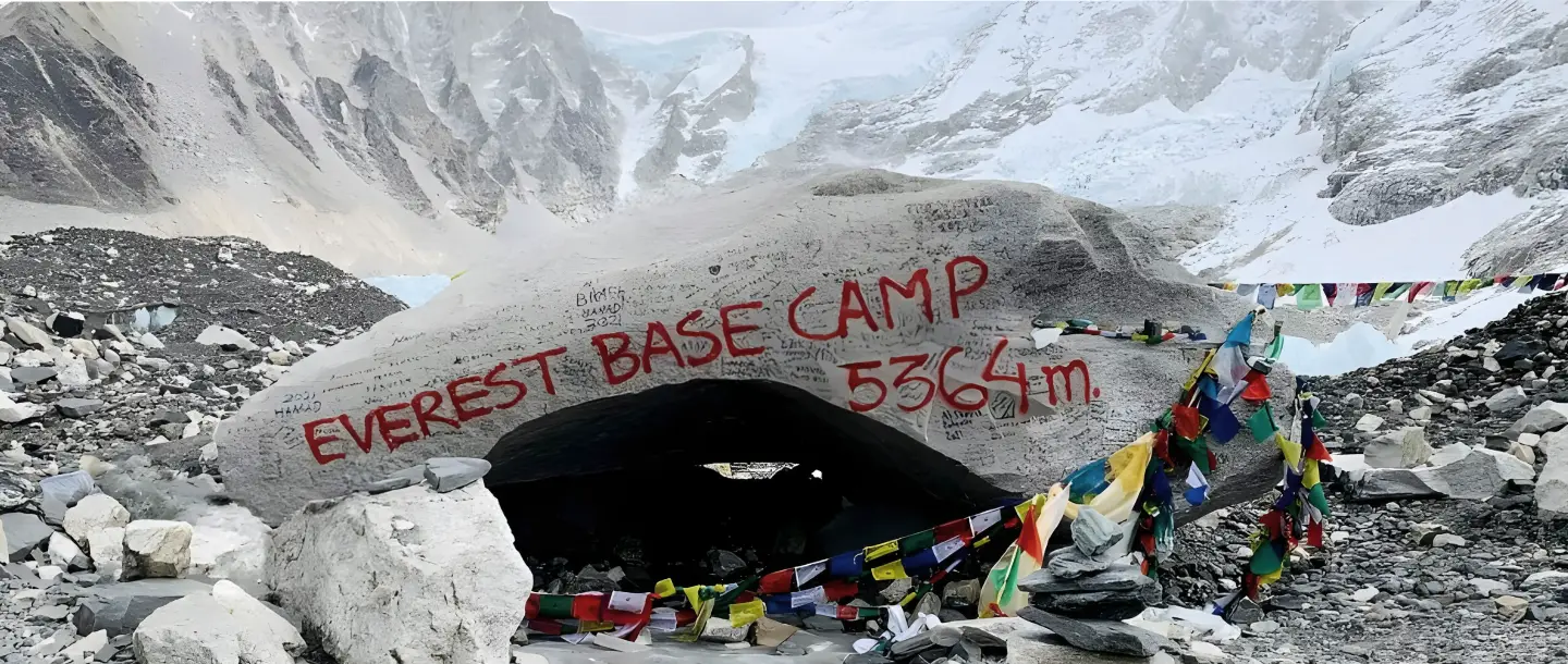
Everest Base Camp Trek: The Complete 2026 Planning Guide
Why Every High-Altitude Trekker Needs These Two Life-Saving Tools (And How to Use Them Properly)
Acclimatiation Process to make your trip successful
