Gokyo Lake Trek
Trip Difficulty: Moderate

Trip Days:12

Max Elevation: 5,357m

Daily Activity: 5-6 hours Trek

Trip Starts: Lukla

Trip Ends: Lukla
If you want the drama of the Everest region without walking in a constant crowd, the Gokyo Lake Trek is the route you’ve been looking for. This journey takes you into the heart of the Khumbu, then veers away from the classic Everest Base Camp highway and climbs toward a chain of turquoise, glacier-fed lakes and a legendary viewpoint—Gokyo Ri (5,357m)—where four 8,000-meter giants line up in a single sweep of Himalayan skyline.
At Kudos Exped, we often describe Gokyo as the trek of “quiet power.” It’s not quiet because it lacks scenery—Gokyo is outrageous in the best way. It’s quiet because the experience feels more spacious: wider valleys, calmer trails, and a more intimate connection to Sherpa villages, yak pastures, and the immense, shifting world of ice.
The Gokyo Lakes sit inside Sagarmatha National Park, Nepal’s high Himalayan protected area that’s also recognized as a UNESCO World Heritage Site. The lakes themselves are widely described as the world’s highest freshwater lake system, clustered at roughly 4,700–5,000m, and formed by ancient glaciers and modern meltwater.
What Makes the Gokyo Lake Trek Special?
Many treks are beautiful. Gokyo is beautiful in a way that feels layered—like the landscape keeps changing its mind as you climb: forest to stone, stone to ice, ice to water, and water to sky.
1) The Gokyo Lakes: A High-Altitude World of Turquoise
Most trekkers first see “Gokyo” and imagine one lake. In reality, the Gokyo system includes six main lakes (and additional smaller wetland areas depending on how you count them), sitting in a stark glacial basin high above the tree line.
What makes these lakes so striking isn’t only the color (though the color is unreal). It’s the setting: ridgelines of rock and ice, wind ripping across open water, and the sensation that you’re standing in a place that belongs more to geology than to human time.
The Gokyo area also has recognized ecological importance. “Gokyo and associated lakes” were designated as a Wetland of International Importance (Ramsar Site), with a designation date listed as 23-09-2007. In practical terms, this means the region isn’t only photogenic—it’s ecologically meaningful, and worth treating with respect: staying on trails, avoiding pollution, and choosing responsible trekking practices.
2) Gokyo Ri (5,357m): A Viewpoint That Competes With Anything in Nepal
The name Gokyo Ri should be on any serious trekker’s bucket list. The climb is steep, often done before sunrise, and it demands patience at altitude—but the payoff is one of the most famous panoramas in the Himalaya.
From the summit, you’re rewarded with a broad “Himalayan amphitheater” that includes views toward Everest and neighboring giants. Unlike some viewpoints that funnel everyone into the same narrow ledge at the same time, Gokyo Ri often feels more open—more room to breathe, to take photos, to just be still and watch sunlight travel across ice.
3) Ngozumpa Glacier: The Immensity of Moving Ice
The Gokyo route gives you a close relationship with the Ngozumpa Glacier, a vast river of debris-covered ice that shapes the valley’s entire personality. Several sources describe it as about 36 km long—a number that helps you understand its scale, even before you see it with your own eyes. (ICIMOD)
Walking near a glacier like this feels different from walking near mountains. Mountains feel permanent. Glaciers feel alive—cracking, shifting, melting, refreezing—quietly changing the map year by year.
4) Sherpa Culture, Villages, and Everyday Mountain Life
Gokyo isn’t only a scenic trek; it’s a cultural journey through settlements like Namche Bazaar and smaller high villages on the way toward the lakes.
On the trail, the details matter: prayer flags cutting the wind, mani walls etched with sacred mantras, the rhythm of yak caravans, and the warmth of teahouse hospitality at the end of a cold day. The Everest region is globally famous, but the human side is what stays with you—shared fires, shared meals, and stories told over cups of hot tea.
Trek Highlights
• Six glacial lakes at extreme altitude
Yes, the lakes are stunning. But the bigger story is how rare it is to see a full high-altitude lake system like this—multiple bodies of water gathered in one basin, fed by glaciers and surrounded by peaks.
For photographers, the lakes create reflections and color contrast that you don’t get on the classic Everest Base Camp route. For trekkers, they create a sense of arrival—like the journey has reached a hidden Himalayan sanctuary.
• Gokyo Ri (5,357m) sunrise climb
The Gokyo Ri ascent is often the most physically demanding single morning of the trek. At this altitude, the air is thinner and each step feels more expensive. What makes it special is not just the view—it’s the process: headlamp beams on stone, frozen breath, a slow steady rhythm, and the moment the horizon turns from black to silver to gold.
• Ngozumpa Glacier exploration
Seeing a glacier from far away is one thing. Being near it—walking along moraines and watching meltwater streams carve paths through rock—creates a new respect for the forces shaping the Himalaya. The Ngozumpa’s scale is often cited at around 36 km, and it dominates the valley like a frozen highway. (ICIMOD)
• Quieter trails than Everest Base Camp
This is one of the biggest reasons experienced trekkers choose Gokyo. The Everest region is popular for a reason, but popularity has side effects: crowded lodges, congested trails, and less flexibility. Gokyo typically offers a calmer rhythm while still delivering major Himalayan viewpoints.
• Optional “circuit” extensions (Renjo La and beyond)
For trekkers who want a more challenging loop, many itineraries extend Gokyo into a circuit via high passes—most famously Renjo La (5,360m).
This transforms the trek from a “valley in and out” to a more complete Khumbu experience, adding wilder terrain and fresh village connections.
Best Time to Do the Gokyo Lake Trek
Most trekkers choose spring (March to May) or autumn (September to November) for stable weather and clear views.
Spring (March–May)
Spring is famous for longer days, clearer mornings, and the feeling that the mountains are “waking up.” Lower elevations bloom with rhododendron, and the Everest region starts to feel lively. Snow can still appear at altitude, but conditions are often ideal for big panoramic days.
Autumn (September–November)
Autumn typically brings crisp air and sharp visibility after the monsoon season. Many people consider this the most reliable season for photography and mountain views. Nights get colder as the season progresses, but stable skies make it a favorite for the Gokyo Ri sunrise.
Winter and Monsoon (What to Expect)
Winter trekking is possible if you are well-prepared, but cold temperatures and snow can add difficulty—especially around high points. It is usually chilly in the morning, but during day time it is very warm. So, it is 100% doable and can be much quieter andmore comfortable.
Monsoon months bring more clouds, rain, and trail complications. In the Everest region, you may still get clear windows, but flights and visibility are less predictable.
Trek Journey (Route Experience)
Even without a day-by-day itinerary, it helps to understand the story arc of the Gokyo Lake Trek—the way the landscape changes and why acclimatization matters.
Stage 1: Lukla to Namche – entering the Khumbu world
After the Lukla gateway, the trail follows river valleys, crosses suspension bridges, and gradually rises toward Namche Bazaar (3,440m), a key acclimatization hub.
Namche isn’t just a stop—it’s where your body begins to learn the rules of altitude. It’s also where you start to feel the cultural pulse of the region: markets, bakeries, gear shops, and the shared excitement of being in the high Himalaya.
Stage 2: Namche to the high villages – leaving crowds behind
After Namche, the Gokyo route splits away from the main Everest Base Camp flow. The trail climbs through forests into more open alpine terrain, passing settlements like Dole (4,200m) and Machhermo (4,470m)—common acclimatization points in many itineraries.
This is where the trek becomes quieter and more meditative. Days feel more spacious. You notice the small things: the direction of wind, the sound of bells on yaks, the way clouds build around ridges in the afternoon.
Stage 3: Arrival at Gokyo – lakes, glacier, and the altitude threshold
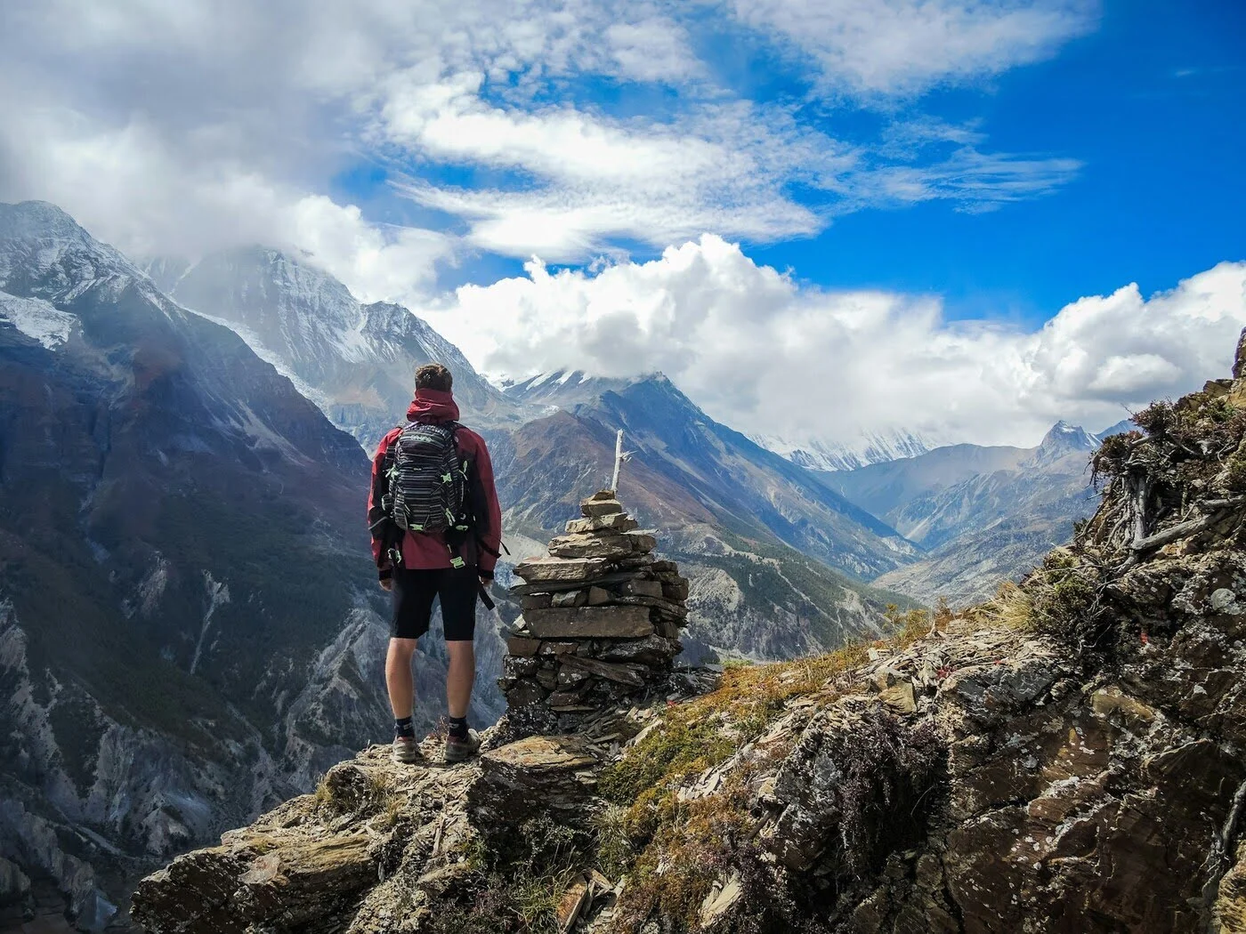
Gokyo village sits near the lake system at around 4,790m in many standard routes. At this altitude, trekking becomes less about speed and more about discipline: steady pacing, hydration, warm layers, and early nights. The reward is that you’re now surrounded by a landscape that feels almost other-worldly—glacial valleys, wind-polished rock, and water that looks like it was poured from a painter’s palette.
Stage 4: Gokyo Ri – the “summit” day of the trek
Gokyo Ri (5,357m) is typically the highest point and the emotional peak of the whole journey.
It’s steep, but non-technical. You don’t need ropes or climbing skills—what you need is patience, a calm rhythm, and respect for altitude. Many trekkers describe the top as a moment that “re-sets” their idea of scale.
Stage 5: Return or circuit – different ways to finish strong
Some trekkers retrace their steps back toward Lukla; others continue as part of a circuit via passes like Renjo La (5,360m).
Either way, the final days often feel lighter—your lungs working better as altitude drops, your legs stronger than they were at the start, and your mind full of mountain memory.
Physical Preparation (How to Train for Success)
The Gokyo Lake Trek is often described as “moderate,” but it’s important to understand what that really means. The trail is moderate in technical terms—there’s no rock climbing, no ropes, and no need for specialized mountaineering skills. However, the effort required is absolutely real. Most trekkers walk around 5–7 hours a day, and those hours are not flat strolls—they include long uphill stretches, steep descents, and repeated altitude gains that can slowly drain your energy if you’re not prepared. The true difficulty shows up higher on the trek, especially above 4,500m, where thin air makes even normal walking feel heavier. That’s why preparing properly isn’t about becoming an athlete—it’s about building the right kind of fitness so the trek feels enjoyable rather than exhausting. At Kudos Exped, we encourage smart training that strengthens your body for long days, helps you recover faster, and reduces your risk of injury.
Building trekking endurance is the foundation. Think of endurance as your “engine”—it’s what allows you to keep moving comfortably for hours without burning out. You don’t need speed; you need consistency. The best preparation is simply time on your feet: long walks, hikes, or stair sessions, ideally on uneven ground because that’s what Himalayan trails are like. Start with what you can manage now and increase gradually until you’re comfortable walking several hours in a day. The goal is to finish a long training hike feeling tired but still functional—because on the trek, you’ll need to wake up and do it again the next morning.
Equally important is strengthening your legs and core, which is like building a strong “chassis” for the journey. Many people assume uphill is the hardest part, but in reality, downhill is where knees, ankles, and thighs take a beating—especially when you’re tired and carrying a daypack. Strong quads, glutes, calves, and core muscles help you stabilize on rocky steps, keep balance on uneven paths, and protect your joints. Training doesn’t need to be complicated: step-ups, lunges, squats, calf raises, and loaded walks (walking with a backpack) are some of the most practical exercises you can do. These movements copy what you’ll do every day on the trek, which is why they make such a big difference once you’re on Himalayan terrain.
To feel better at altitude, you should also improve cardiovascular fitness—your “altitude buffer.” Altitude reduces oxygen availability, which means your heart and lungs must work harder for the same effort. Cardio training can’t replace acclimatization, but it helps your body become more efficient and makes daily trekking feel smoother. Simple activities like running, cycling, swimming, brisk hill-walking, or stair climbing build endurance and improve recovery. The benefit is huge: you’ll breathe better, feel less drained at the end of the day, and recover more quickly overnight, which keeps your energy stable across the whole trek.
Finally, don’t ignore trekking habits, because small mistakes can cause big problems in the mountains. Blisters, cold exposure, dehydration, and poor layering choices can ruin your trek faster than sore legs. Before you arrive, break in your boots properly, test different socks, and learn what causes hotspots on your feet. Practice walking with a backpack so your shoulders and hips adjust. Learn layering so you don’t sweat too much on climbs and then freeze when you stop—this is one of the most common comfort mistakes in the Himalaya. When you prepare these details in advance, your body can focus on trekking rather than managing preventable discomfort.
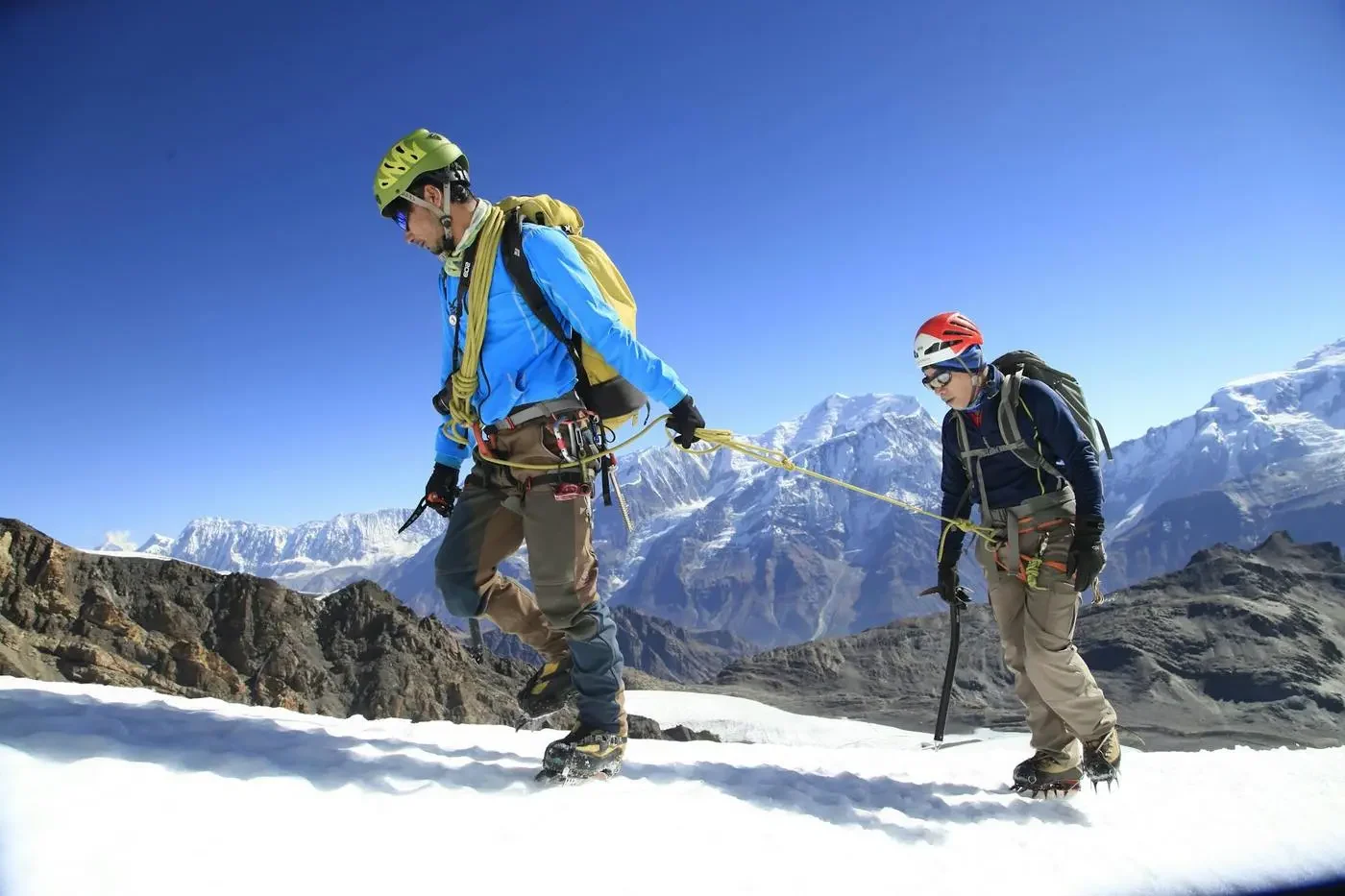
Altitude & Acclimatization (The Most Important Topic)
Altitude is the single most important factor on the Gokyo Lake Trek. The trek climbs above 5,000m, with the highest point at Gokyo Ri (5,357m). At that height, the biggest risk isn’t tired legs—it’s how your body responds to thin air. Altitude Sickness (AMS) can affect anyone, regardless of age, fitness, or trekking experience. You can be extremely strong at sea level and still struggle at high altitude, because acclimatization is not about muscle strength—it’s about how your body adapts to reduced oxygen. This is why altitude should never be treated casually. The smartest approach is to respect the mountain environment, follow a steady pace, and build a trek schedule that allows the body time to adjust.
The acclimatization rule that saves treks is simple but powerful: climb high, sleep low whenever possible, and increase sleeping altitude gradually. This is why acclimatization hikes are so effective—your body gets exposure to higher elevation during the day, then recovers at a slightly lower sleeping altitude at night. Another key factor is pace. Moving slowly may feel frustrating at first, but it’s often the difference between feeling strong on day eight versus getting sick on day five. Hydration matters too—your body loses moisture faster at altitude, and dehydration can make AMS symptoms worse or more confusing. Most importantly, never dismiss warning signs. Headache, nausea, dizziness, extreme fatigue, loss of appetite, or poor sleep can be early indicators of AMS. These symptoms are not “normal trekking discomfort.” They are signals that your body needs more time, more rest, or sometimes a descent.
At Kudos Exped, we design the trek rhythm around acclimatization because it’s the difference between a trek you merely complete and a trek you truly enjoy. When acclimatization is done properly, you don’t just reach Gokyo—you reach it with the energy to appreciate the lakes, the glacier, and the sunrise from Gokyo Ri. And that’s the real goal: not rushing through a famous route, but experiencing it safely, comfortably, and fully.
Food & Water (How to Stay Strong in the Mountains)
Food on the Gokyo trek is designed for energy, warmth, and practicality. Many trekkers rely on meals like dal bhat, noodles, soups, potatoes, rice dishes, eggs, and local breads.
What good mountain eating looks like
- Prioritize carbohydrates for trekking fuel at altitude.
- Eat consistently, even when appetite dips higher up.
- Go easy on alcohol, especially above Namche, because it can worsen dehydration and acclimatization challenges.
Water safety (don’t gamble with your stomach)
In high places, stomach issues can ruin a trek faster than steep hills. Use purification methods, drink enough, and aim for steady hydration throughout the day.
Permits & Entry Requirements (What You Need for Gokyo)
For the Gokyo Lake Trek, two permits are commonly required:
- Sagarmatha National Park Entry Permit
- Khumbu Pasang Lhamu Rural Municipality Permit
These are widely referenced as the standard requirements for trekking in this part of the Everest region, and they support conservation and local infrastructure.
Safety Considerations (How Kudos Exped Approaches It)
Trekking safety in the Himalaya is not one single decision—it’s a chain of good decisions.
Weather and flight delays are real
In the Everest region, weather is not just a background detail—it can actively shape your entire trekking schedule. Conditions can shift quickly from bright blue skies to cloud build-up, strong winds, or poor visibility, especially around Lukla and the high valleys. Because Lukla airport sits in a mountainous setting where visibility and wind are critical for safe landings and takeoffs, flights are sometimes delayed for hours, pushed to the next day, or canceled altogether. This is normal in the Khumbu, not an exception. That’s why a smart Gokyo Lake Trek plan with Kudos Exped always includes a realistic approach: keeping buffer days, staying flexible with travel timing, and mentally preparing for schedule changes without stress. When you treat delays as part of the journey instead of a disaster, you protect your energy, enjoy the trek more, and make safer decisions throughout the trip.
Altitude management is non-negotiable
The Gokyo Lake Trek reaches extreme elevations, with the high point at Gokyo Ri (5,357m), and at these heights your body must adjust to thinner air and lower oxygen levels. This is why altitude safety is directly connected to proper acclimatization, pacing, hydration, and rest. Many trekkers make the mistake of rushing because the trail doesn’t look technically difficult—but altitude doesn’t care how strong you feel at lower elevations. Above 4,000m, even fit hikers can develop symptoms like headache, nausea, dizziness, fatigue, or disturbed sleep. The safest trekkers aren’t the ones who race ahead; they are the ones who move steadily, take acclimatization seriously, and pay attention to what their body is telling them each day. With Kudos Exped, the goal is never to “conquer” altitude—it’s to respect it, so you can reach Gokyo safely and actually enjoy the lakes, glacier views, and summit morning without putting your health at risk.
Trekking with experienced leadership matters
A route can look simple on a map, but real safety in the mountains depends on decisions made in real time—especially at altitude. Weather changes, trail conditions, health signals, and group pace all interact, and knowing what to do requires experience. Good leadership means more than guiding the way; it includes managing daily walking speed, building acclimatization into the rhythm of the trek, and spotting early warning signs of AMS (Acute Mountain Sickness) before they become serious. An experienced guide also knows when to encourage rest, when to adjust the plan, and when it’s safer to descend rather than push higher. This kind of judgment can’t be replaced by reading blogs or following a GPS track. When you trek with Kudos Exped, you’re not only hiring someone to show the trail—you’re relying on practical mountain expertise that protects your health, reduces risk, and increases the chance that your trek finishes successfully and comfortably.
Responsible trekking: protecting what we came to see
Gokyo is not only a spectacular trekking destination—it’s a fragile high-altitude ecosystem that has international conservation importance. That matters because the environment here is slow to recover: waste breaks down very slowly in cold alpine conditions, water sources are sensitive, and wildlife habitats can be disturbed easily. Responsible trekking starts with small daily choices that add up to a major difference. Minimizing plastic waste by carrying reusable bottles and avoiding unnecessary packaging helps reduce pollution in villages and along trails. Refilling water responsibly—using safe filtration or purification—reduces the demand for plastic bottles that must be transported and disposed of in difficult terrain. Staying on established paths prevents erosion and protects delicate ground vegetation that can take years to regrow. Respecting monasteries, prayer walls, and local customs supports the Sherpa cultural identity that gives the region its soul. And treating wildlife and fragile terrain with care keeps the ecosystem balanced and healthy for the future.
When trekkers and operators protect Gokyo, they protect more than scenery. They help preserve the region for future travelers, and they support the livelihoods of local communities who depend on tourism, hospitality, and mountain services. Responsible travel is not about being perfect—it’s about being mindful, so the Gokyo Valley remains clean, respected, and sustainable for generations to come.
Conclusion
The Gokyo Lake Trek is one of the Everest region’s most rewarding journeys: a route of turquoise lakes at 4,700–5,000m, a world-class summit viewpoint at Gokyo Ri (5,357m), and the raw scale of the Ngozumpa Glacier stretching deep into the Khumbu.
It’s also a trek with meaning beyond scenery—inside a protected national park recognized internationally, and within a wetland system designated for its ecological importance.
If you’re looking for an Everest-region adventure that feels both iconic and calmer—big mountains, fewer crowds, deep cultural texture, and landscapes that don’t look real until you’re standing inside them—then Gokyo is your trail. And when you’re ready to turn that dream into a plan, Kudos Exped is here to guide you into the quiet, powerful beauty of the Gokyo Valley.
Standard Gokyo Lake Trek Itinerary
Things Included in Trip cost
Things Not Included in Trip cost
Gokyo Lake Trek Trek MAP
Book Now
💬 Talk to Ang on WhatsApp
Join fixed Departure with Ang
Departing Dates
and Price
Availability
22 May, 2026 - 31 May, 2026
$ 2100
1
Must Know Before your Trip

Why Every High-Altitude Trekker Needs These Two Life-Saving Tools (And How to Use Them Properly)
Acclimatiation Process to make your trip successful
Why Trekkers Fail to Reach the Final Point in Nepal
Nepal Visa Information 2025: Complete Guide for Trekkers & Travelers